
As an Amazon Associate, I earn from qualifying purchases.
In this article 9 sections
- Orienting Yourself: The Pacific Ocean During La Niña
- The Key Players in La Niña
- Normal, El Niño, and La Niña: Three-Way Comparison
- How La Niña Develops: The Causal Chain
- Why La Niña Often Follows El Niño
- La Niña Duration: Why It Lasts Longer Than El Niño
- How NOAA Measures La Niña
- Related Topics in the ENSO Cluster
- Frequently Asked Questions
The short answer: La Niña develops when the trade winds strengthen beyond their normal intensity, pushing warm surface water further west than usual. This exposes cooler water in the central and eastern equatorial Pacific through enhanced upwelling. The Walker Circulation intensifies, sea surface temperatures fall below average, and rainfall shifts westward. La Niña is the cold phase of the ENSO cycle: the opposite of El Niño in almost every respect.
- Strengthened trade winds are the trigger for La Niña: the opposite of El Niño's weakened winds
- Warm water is pushed further west, exposing cooler subsurface water in the eastern Pacific
- Enhanced cold upwelling off South America is the defining ocean characteristic of La Niña
- La Niña typically lasts 1 to 3 years: longer than El Niño's typical 9 to 12 months
- La Niña frequently follows El Niño as trade winds rebound after the warm phase ends

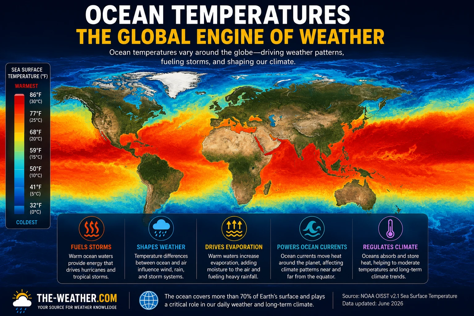
La Niña sea surface temperature anomalies show cool water dominating the central and eastern equatorial Pacific as strengthened trade winds drive enhanced upwelling.
This page covers the complete La Niña causal chain, from trade wind strengthening through thermocline shallowing, enhanced upwelling, and the feedback processes that sustain it. For a comparison of both phases and their global effects see our complete ENSO explainer. For the El Niño mechanism specifically see What Causes El Niño.
2026 El Niño update: NOAA's update of October 8, 2026: a strong-to-very strong El Niño is likely through January to March 2027 (a greater than 83% chance). What that could mean where you live: how strong could the 2026 El Niño become, with regional pages for California, Colorado and the Rockies and the Midwest.
Orienting Yourself: The Pacific Ocean During La Niña
The La Niña mechanism plays out across the full width of the equatorial Pacific, roughly 10,000 miles from Indonesia in the west to Peru in the east. Knowing where key locations sit helps when reading about warm pool, upwelling, and sea surface temperature changes.
During La Niña, strengthened trade winds drive warm water further into the western warm pool while exposing cool water through upwelling in the east. The Niño 3.4 region is where NOAA measures the temperature anomaly that defines La Niña conditions.
The Key Players in La Niña
La Niña involves the same ocean-atmosphere system as El Niño, but driven in the opposite direction. The five entities below explain the cold phase mechanism.
Trade winds that blow stronger than normal push warm surface water further west than usual. This is the primary trigger for La Niña: the opposite of El Niño's wind weakening.
As warm water moves west, the thermocline in the eastern Pacific shallows, bringing cold nutrient-rich deep water closer to the surface. Enhanced upwelling cools the eastern Pacific and defines La Niña conditions.
The stronger east-west temperature contrast during La Niña intensifies the Walker Circulation: the opposite of El Niño's weakening effect. More vigorous rising air over the western Pacific drives stronger trade winds, reinforcing the La Niña state.
During La Niña, upwelling Kelvin waves propagate eastward along the equator, shallowing the thermocline in the eastern Pacific rather than deepening it. The opposite of the downwelling waves that amplify El Niño.
The thermocline sits closer to the surface in the eastern Pacific during La Niña, making cold upwelling more efficient and persistent. This maintains the cool sea surface temperatures that define the cold phase.
Normal, El Niño, and La Niña: Three-Way Comparison
- Trade winds moderate
- Warm pool in western Pacific
- Thermocline moderate depth
- Moderate upwelling east
- Walker Circulation normal
- Trade winds weaken
- Warm water spreads east
- Thermocline deepens east
- Upwelling suppressed
- Walker Circulation weakens
- Trade winds strengthen
- Warm water pushed further west
- Thermocline shallows east
- Enhanced cold upwelling
- Walker Circulation intensifies
How La Niña Develops: The Causal Chain

La Niña's causal chain: the mirror of El Niño's mechanism, driven by strengthened rather than weakened trade winds.
Trade winds strengthen beyond normal
La Niña begins when the trade winds strengthen beyond their climatological average. This often happens as El Niño ends and the trade winds rebound, sometimes more forcefully than usual, but La Niña can also develop directly from neutral conditions. The trigger is typically a combination of the seasonal cycle, upwelling Kelvin waves reflecting off the South American coast, and random atmospheric variability reinforcing each other.
Warm water pushed further west
Stronger than normal trade winds increase the westward transport of warm surface water across the Pacific. The warm pool in the western Pacific near Australia and Indonesia becomes larger and deeper than usual. Sea surface temperatures in the central and eastern Pacific begin to fall as the warm water is effectively swept away to the west.
Thermocline shallows in the eastern Pacific
With warm water removed from the eastern Pacific, the thermocline, the boundary between warm surface water and cold deep water, rises closer to the surface. Upwelling Kelvin waves propagating eastward along the equator reinforce this shallowing as they lift the thermocline further toward the surface across the central and eastern Pacific.
Enhanced cold upwelling cools the eastern Pacific
With the thermocline close to the surface, wind-driven upwelling efficiently brings cold subsurface water to the surface across the central and eastern equatorial Pacific. Sea surface temperatures fall below the long-term average, when the 3-month average Niño 3.4 anomaly reaches -0.5°C, NOAA officially declares La Niña conditions.
Walker Circulation intensifies: and reinforces La Niña
The larger east-west temperature contrast, cool east, warm west, intensifies the Walker Circulation beyond its normal strength. More vigorous rising air over the warm western Pacific drives stronger outflow at altitude, stronger sinking over the cool eastern Pacific, and stronger surface trade winds returning westward. This intensification is itself a feedback loop: stronger trade winds maintain and deepen La Niña conditions, which sustains the strong Walker Circulation, which maintains the strong trade winds. This feedback is why La Niña tends to last longer than El Niño.
Why La Niña Often Follows El Niño
The transition from El Niño to La Niña is one of the most consistent patterns in ENSO science, though it is not guaranteed after every event. Several mechanisms make this transition common:
- Trade wind rebound: As El Niño's warming weakens, the east-west temperature contrast begins to re-establish itself, driving a recovery of the trade winds. This rebound is often stronger than the pre-El Niño baseline, providing the initial push toward La Niña conditions.
- Upwelling Kelvin wave reflection: The downwelling Kelvin waves that carried warm water eastward during El Niño onset eventually reflect off the South American coast as upwelling Kelvin waves. These reflected waves travel back westward, shallowing the thermocline as they go and helping to expose cold water in the eastern Pacific.
- Seasonal forcing: The annual cycle of solar radiation imposes a seasonal rhythm that tends to weaken El Niño by spring in the Northern Hemisphere, sometimes providing enough nudge to push conditions past neutral into La Niña territory.
La Niña Duration: Why It Lasts Longer Than El Niño
La Niña typically lasts longer than El Niño for a fundamental reason: the feedback mechanisms that sustain it are more self-reinforcing. During El Niño, the warm water reservoir that fuels the event is finite and gradually depleted as warm water spreads east. During La Niña, there is no equivalent reservoir constraint: the cold water available through upwelling is effectively unlimited, and the intensified Walker Circulation continuously reinforces the conditions that sustain it.
The Triple-Dip La Niña: 2020 to 2023
The most recent extended La Niña episode produced three consecutive Northern Hemisphere winters of La Niña conditions: one of only a handful of triple-dip events in the modern record. Each winter produced above-normal Atlantic hurricane activity and drier conditions across the southern US.
How NOAA Measures La Niña
La Niña is not declared on a single measurement: NOAA requires both an ocean signal and a coupled atmospheric response before issuing an official declaration. The five components of that assessment:
- Niño 3.4 region: The monitoring area in the central equatorial Pacific (5°N–5°S, 170°W–120°W) where sea surface temperature anomalies are measured.
- Oceanic Niño Index (ONI): The 3-month running average of Niño 3.4 sea surface temperature anomalies. This is NOAA's primary metric for ENSO phase classification.
- The -0.5°C threshold: When the ONI reaches -0.5°C or below for at least 5 consecutive overlapping 3-month periods, La Niña is officially declared.
- Coupled atmosphere-ocean response: Ocean cooling alone is not sufficient. NOAA also requires the atmosphere to show a coupled response: the Walker Circulation must be measurably intensified and the Southern Oscillation Index must confirm the atmospheric component of the cold phase.
- Strength categories: Weak (-0.5 to -0.9°C), Moderate (-1.0 to -1.4°C), Strong (-1.5 to -1.9°C), and Very Strong (-2.0°C or below): based on the peak ONI value during the event.
Related Topics in the ENSO Cluster
Frequently Asked Questions
What causes La Niña?
La Niña develops when the trade winds strengthen beyond normal, pushing warm surface water further west than usual. This exposes cooler water in the central and eastern equatorial Pacific through enhanced upwelling, lowering sea surface temperatures below average. The Walker Circulation intensifies and La Niña's global weather impacts follow.
What is the difference between La Niña and El Niño causes?
El Niño begins when trade winds weaken, allowing warm water to slosh eastward. La Niña is the opposite: trade winds strengthen beyond normal, pushing warm water further west and exposing cooler water in the east through enhanced upwelling. Both involve the same Walker Circulation and thermocline mechanisms, driven in opposite directions.
Why does La Niña often follow El Niño?
As El Niño ends, trade winds typically rebound more strongly than normal, driven by upwelling Kelvin waves reflecting off the South American coast and the seasonal cycle restoring the east-west temperature gradient. These stronger-than-normal winds then push warm water further west than usual, triggering La Niña through the same feedback mechanisms as El Niño, but in reverse.
How long does La Niña last?
La Niña typically lasts 1 to 3 years: longer on average than El Niño events, which usually last 9 to 12 months. Some events persist for multiple consecutive Northern Hemisphere winters, as occurred during the triple-dip La Niña of 2020 to 2023.
How trade wind weakening, Kelvin waves, and the Bjerknes feedback drive the warm phase of ENSO.
The complete ENSO overview covering weather impacts, hurricane season effects, and historic events.
Sources
- NOAA Climate.gov: La Niña mechanism and ENSO explainer
- NOAA Climate Prediction Center: Oceanic Niño Index: historic La Niña event records
- WMO: ENSO cold phase reference
No manufacturer compensation received. Science sourced from official NOAA and WMO references.

Lena Thornton
Weather Station Analyst & CWOP Contributor. Lena researches atmospheric science and ENSO dynamics, translating complex ocean-atmosphere mechanisms into accessible explanations. Published July 2026.