
We may earn a commission when you buy through links on this page, at no extra cost to you. Learn more
In this article 6 sections
The short answer: El Niño begins when the trade winds that normally blow westward across the tropical Pacific weaken or reverse. Without strong winds holding it back, warm water accumulated in the western Pacific sloshes eastward. This warms the central and eastern Pacific, weakens the Walker Circulation, and triggers the rainfall, temperature, and hurricane season impacts associated with El Niño. The Bjerknes feedback loop amplifies the event once it begins.
- Trade wind weakening is the trigger, without it El Niño cannot develop
- The Walker Circulation drives the normal east-west atmospheric pattern that El Niño disrupts
- Kelvin waves carry warm water eastward along the equator once trade winds weaken
- The thermocline deepens in the eastern Pacific, allowing warm water to dominate the surface
- The Bjerknes feedback is a self-amplifying loop that makes El Niño grow once started
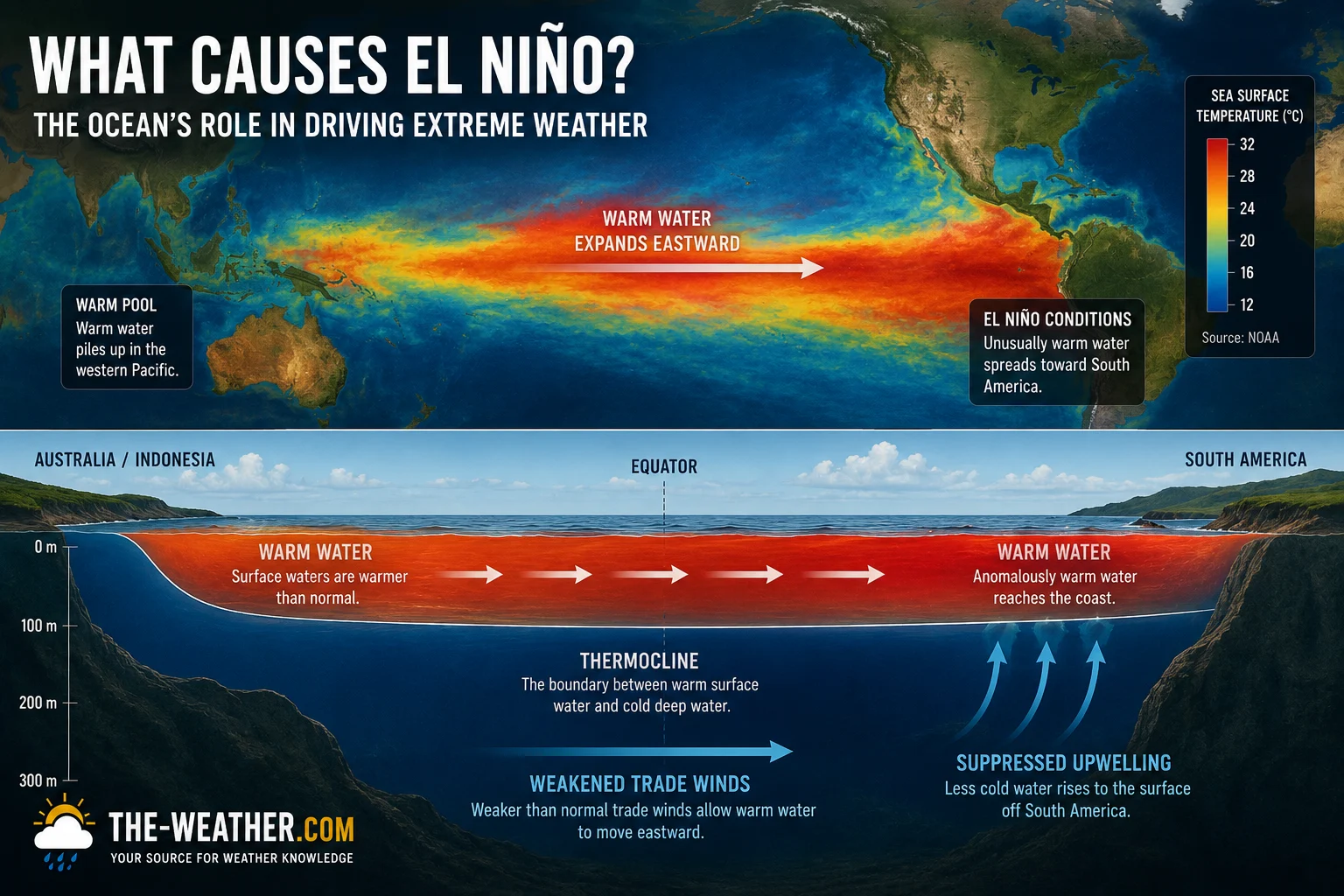
El Niño sea surface temperature anomalies show the warm water plume spreading across the central and eastern equatorial Pacific as trade winds weaken.
This page covers the complete causal chain, from trade wind weakening through Walker Circulation breakdown, Kelvin wave propagation, thermocline deepening, and the Bjerknes feedback loop. For a broader overview of El Niño and La Niña effects see our complete ENSO explainer.
2026 El Niño update: NOAA now gives a greater than 90% chance of a very strong El Niño this winter. What that could mean where you live: how strong could the 2026 El Niño become, with regional pages for California, Colorado and the Rockies and the Midwest.
The Key Players in El Niño
Before tracing the causal chain, it helps to understand the five entities involved. Each plays a specific role in the El Niño mechanism.
Surface winds that blow westward across the tropical Pacific year-round. They are the primary driver of normal ocean circulation, and their weakening is the trigger for El Niño.
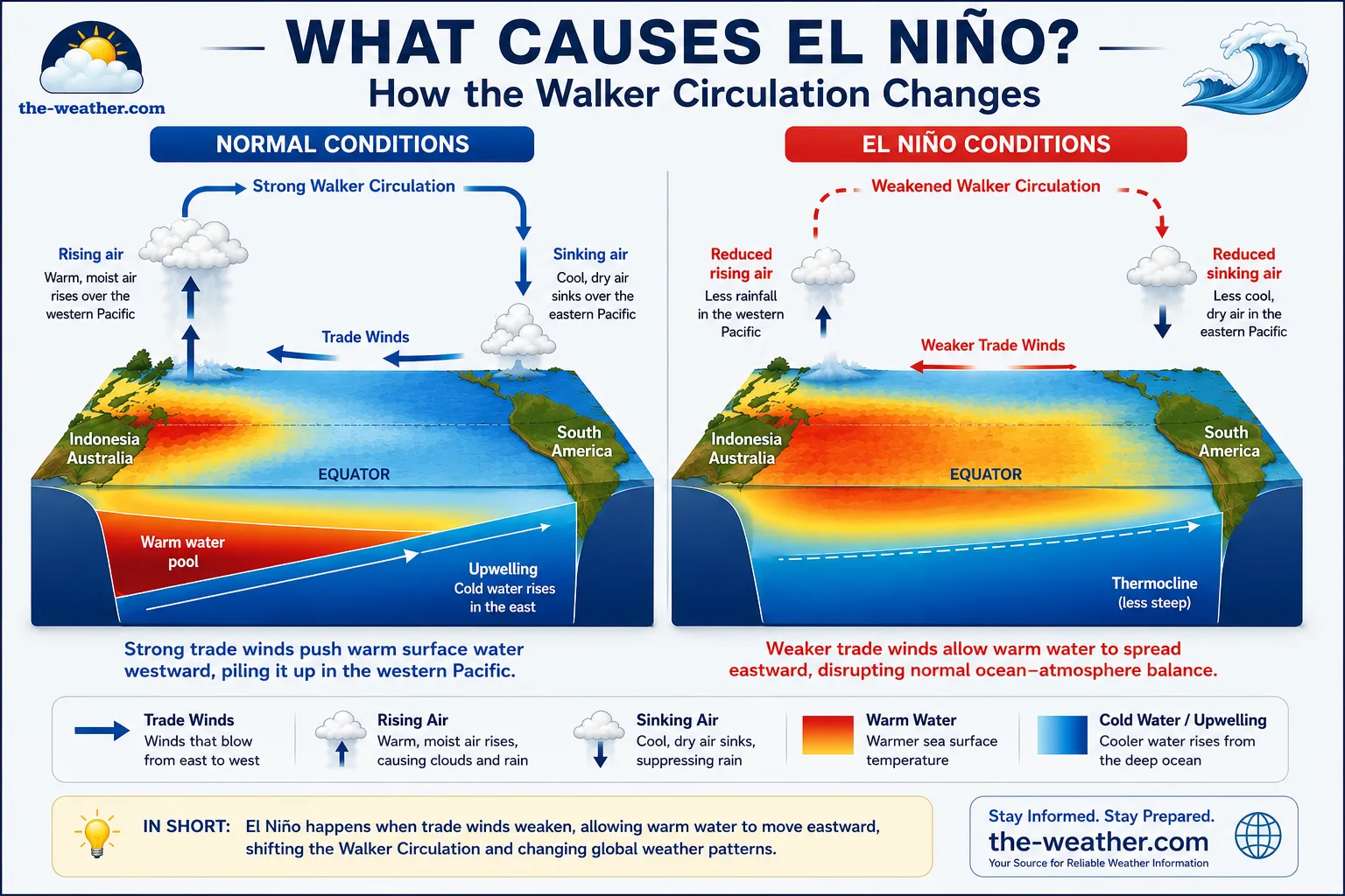
The large atmospheric loop that circulates air east to west across the tropical Pacific. Named after Gilbert Walker who identified it in the early 20th century. El Niño weakens or reverses it.
The boundary between warm surface water and cold deep water in the ocean. Normally shallow in the eastern Pacific: allowing cold water to upwell. El Niño deepens it, cutting off the cold upwelling.
Eastward-propagating pulses of warm water that travel along the ocean surface and thermocline at the equator. They carry the El Niño warming signal from the western Pacific to the east in 2 to 3 months.
The self-amplifying feedback loop identified by Norwegian meteorologist Jacob Bjerknes in 1969. Once El Niño starts, this loop makes it grow: each step reinforces the next until the warm water is eventually depleted.
Normal Pacific Conditions vs El Niño
- Trade winds blow strongly westward
- Warm water pools in western Pacific near Australia
- Thermocline shallow in eastern Pacific
- Cold water upwells off South America
- Heavy rainfall over western Pacific
- Walker Circulation strong
- Trade winds weaken or reverse
- Warm water spreads eastward across Pacific
- Thermocline deepens in eastern Pacific
- Cold upwelling suppressed off South America
- Rainfall shifts eastward toward central Pacific
- Walker Circulation weakened or reversed
How El Niño Develops: The Causal Chain
The El Niño causal chain from initial trade wind weakening through Bjerknes feedback amplification.
Trade winds weaken
The process begins when the normally strong westward trade winds across the tropical Pacific weaken, sometimes to near-calm or even brief reversals. The trigger for this weakening is not fully understood, random atmospheric variability, the Madden-Julian Oscillation, and seasonal forcing all play a role, but the outcome is clear: the surface winds that hold the warm water in the western Pacific lose their grip.
Kelvin waves carry warm water east
When trade winds weaken, they trigger downwelling oceanic Kelvin waves: eastward-propagating pulses that travel along the equatorial Pacific at roughly 2.5 metres per second. These waves carry the warm water signal from the western Pacific eastward, deepening the thermocline as they go. A single Kelvin wave crosses the full width of the Pacific in approximately 2 to 3 months.
Thermocline deepens in the east
As the Kelvin waves arrive in the eastern Pacific, they push the thermocline deeper. In normal conditions, the thermocline is shallow enough in the eastern Pacific that cold deep water upwells to the surface off the South American coast. When El Niño deepens the thermocline, this cold upwelling is suppressed, and the warmer water that has arrived dominates the surface instead.
Sea surface temperatures rise in the central and eastern Pacific
The combination of eastward-advected warm water and suppressed cold upwelling raises sea surface temperatures across the Niño 3.4 monitoring region: the central equatorial Pacific between 5°N and 5°S, 170°W and 120°W. When the 3-month average anomaly in this region reaches +0.5°C, NOAA officially declares El Niño conditions. The 2026 event reached +1.7°C on the weekly index by mid-June, already in strong territory.
Atmospheric circulation responds
The warmer eastern Pacific drives more evaporation and convection in a region that normally sees suppressed rainfall. The rising air over the eastern Pacific shifts the Walker Circulation, reducing the pressure gradient between east and west that normally drives the trade winds. Rainfall patterns shift eastward from the western Pacific toward the central Pacific.
The Bjerknes Feedback: Why El Niño Amplifies Itself
Once El Niño begins, the Bjerknes feedback, named after Norwegian meteorologist Jacob Bjerknes who identified it in 1969, creates a self-reinforcing loop that amplifies the event. Each step weakens the trade winds further, which allows more warm water to move east, which further weakens the trade winds.
The Bjerknes feedback explains why El Niño events that start weakly can grow to strong or very strong intensity over several months: the process is self-sustaining once triggered.
How the 2026 El Niño Fits This Pattern
The 2026 event is following the classic El Niño development sequence described above. Trade winds across the tropical Pacific began weakening in early 2026, triggering the sequence of Kelvin wave propagation and thermocline deepening that produced the rapid rise in Niño 3.4 index values observed through the spring and early summer. The weekly Niño 3.4 index reached +1.7°C by mid-June 2026: consistent with a rapidly amplifying event driven by active Bjerknes feedback.
Why El Niño Eventually Ends
El Niño cannot sustain itself indefinitely. Several processes work to end it:
- Warm water reservoir depletion: The western Pacific warm water pool that fuels El Niño is finite. As warm water moves east over months, the supply in the west diminishes and the temperature anomaly in the east eventually begins to weaken.
- Upwelling Kelvin waves: After downwelling Kelvin waves propagate eastward during El Niño onset, they reflect off the South American coast as upwelling Kelvin waves and travel back westward. These returning waves bring cooler water back to the surface and help terminate the event.
- Seasonal forcing: The annual cycle of solar radiation imposes a seasonal rhythm on Pacific Ocean temperatures that tends to force El Niño events to peak in Northern Hemisphere winter and weaken by spring.
- La Niña rebound: As El Niño ends, the trade winds often rebound more strongly than normal, triggering La Niña through the same feedback mechanism in reverse. This is why La Niña frequently follows El Niño within 12 to 18 months: see our What Causes La Niña page for the mechanism in detail.
Frequently Asked Questions
What causes El Niño?
El Niño begins when the trade winds that normally blow westward across the tropical Pacific weaken or reverse. Without strong winds holding it back, warm water accumulated in the western Pacific sloshes eastward via Kelvin waves. This warms the central and eastern Pacific, weakens the Walker Circulation, and triggers El Niño's global weather impacts via the Bjerknes feedback loop.
What is the Walker Circulation?
The Walker Circulation is a large atmospheric loop circulating air across the tropical Pacific. Under normal conditions, air rises over the warm western Pacific, flows east at high altitude, sinks over the cooler eastern Pacific, and returns westward near the surface as the trade winds. El Niño weakens or reverses it as warm water spreads eastward.
What is the Bjerknes feedback?
The Bjerknes feedback is the self-amplifying cycle that makes El Niño grow once started. Weaker trade winds allow warm water to move east, which further reduces the pressure gradient, which further weakens the trade winds, which allows more warm water to move east. Each step reinforces the next until the warm water reservoir depletes.
What are Kelvin waves in El Niño?
Kelvin waves are eastward-propagating pulses of warm water that travel along the equatorial Pacific at roughly 2.5 metres per second, crossing the Pacific in 2 to 3 months. During El Niño onset, downwelling Kelvin waves carry the warm water signal east and deepen the thermocline, suppressing cold upwelling off South America.
The complete ENSO overview covering global impacts, historic events, and the Niño 3.4 index.
The 2026 event is following this exact causal pattern: Niño 3.4 already at +1.7°C and rising.
Sources
- NOAA Climate.gov: ENSO mechanism and Walker Circulation explainer
- NOAA GFDL: Pacific Ocean dynamics and ENSO research
- WMO: ENSO mechanism reference
- Bjerknes (1969): "Atmospheric teleconnections from the equatorial Pacific": Monthly Weather Review. Original Bjerknes feedback identification paper.
No manufacturer compensation received. Science sourced from official NOAA, WMO, and peer-reviewed references.

Lena Thornton
Weather Station Analyst & CWOP Contributor. Lena researches atmospheric science and ENSO dynamics, translating complex ocean-atmosphere mechanisms into accessible explanations. Updated June 2026.