
As an Amazon Associate, I earn from qualifying purchases.
In this article 7 sections
The short answer: Trade winds are the surface winds that blow westward across the tropical Pacific year-round. They are the single most important variable in the ENSO cycle. When they weaken, El Niño develops. When they strengthen beyond normal, La Niña develops. The Walker Circulation, the large atmospheric loop trade winds are part of, is the mechanism connecting wind strength to sea surface temperatures worldwide.
- Trade winds blow westward across the tropical Pacific, pushing warm water toward Asia and Australia
- Sustained trade wind weakening initiates the chain of events that can develop into El Niño: short-lived weakening alone does not guarantee development
- Trade wind strengthening beyond normal drives La Niña: warm water pushed further west, cold upwelling enhanced
- The Walker Circulation is the atmospheric loop trade winds are part of: it weakens during El Niño and intensifies during La Niña
- The Bjerknes feedback makes trade wind changes self-amplifying: a small initial change grows into a full ENSO event
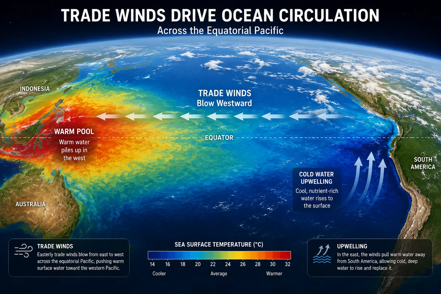
Trade winds blow westward across the equatorial Pacific year-round: their strength is the key variable that determines whether El Niño or La Niña develops.
This page covers what trade winds are, why they blow, how their strength controls the ENSO cycle, and the Walker Circulation that connects wind patterns to global weather. It is the final piece of the ENSO science cluster alongside What Causes El Niño, What Causes La Niña, and Understanding ENSO.
2026 El Niño update: NOAA now gives a greater than 90% chance of a very strong El Niño this winter. What that could mean where you live: how strong could the 2026 El Niño become, with regional pages for California, Colorado and the Rockies and the Midwest.
What Are Trade Winds?
Trade winds are the persistent surface winds that blow from east to west across the tropical belt of the Pacific, Atlantic, and Indian Oceans, roughly between 30°N and 30°S latitude. They are among the most consistent wind patterns on Earth: blowing day and night, season after season, with only modest variation in direction.
Trade winds form because of the pressure gradient between the subtropical high-pressure zones on either side of the equator and the equatorial low-pressure zone. Warm air rises at the equator, creating low pressure. Cooler, denser air from the subtropical highs flows toward the equator to replace it. The Earth's rotation deflects this flow westward through the Coriolis effect, producing the characteristic east-to-west trade wind direction.
In the Pacific, trade winds play a second role beyond simple air movement: they drive ocean circulation. By pushing surface water westward, they pile up warm water in the western Pacific near Australia and Indonesia, creating the warm pool that fuels the Walker Circulation. The thermocline in the western Pacific sits deeper because of this piled-up warm water, while in the east it sits shallower, allowing cold water to upwell to the surface off South America.
Trade Wind Strength Across the Three ENSO States
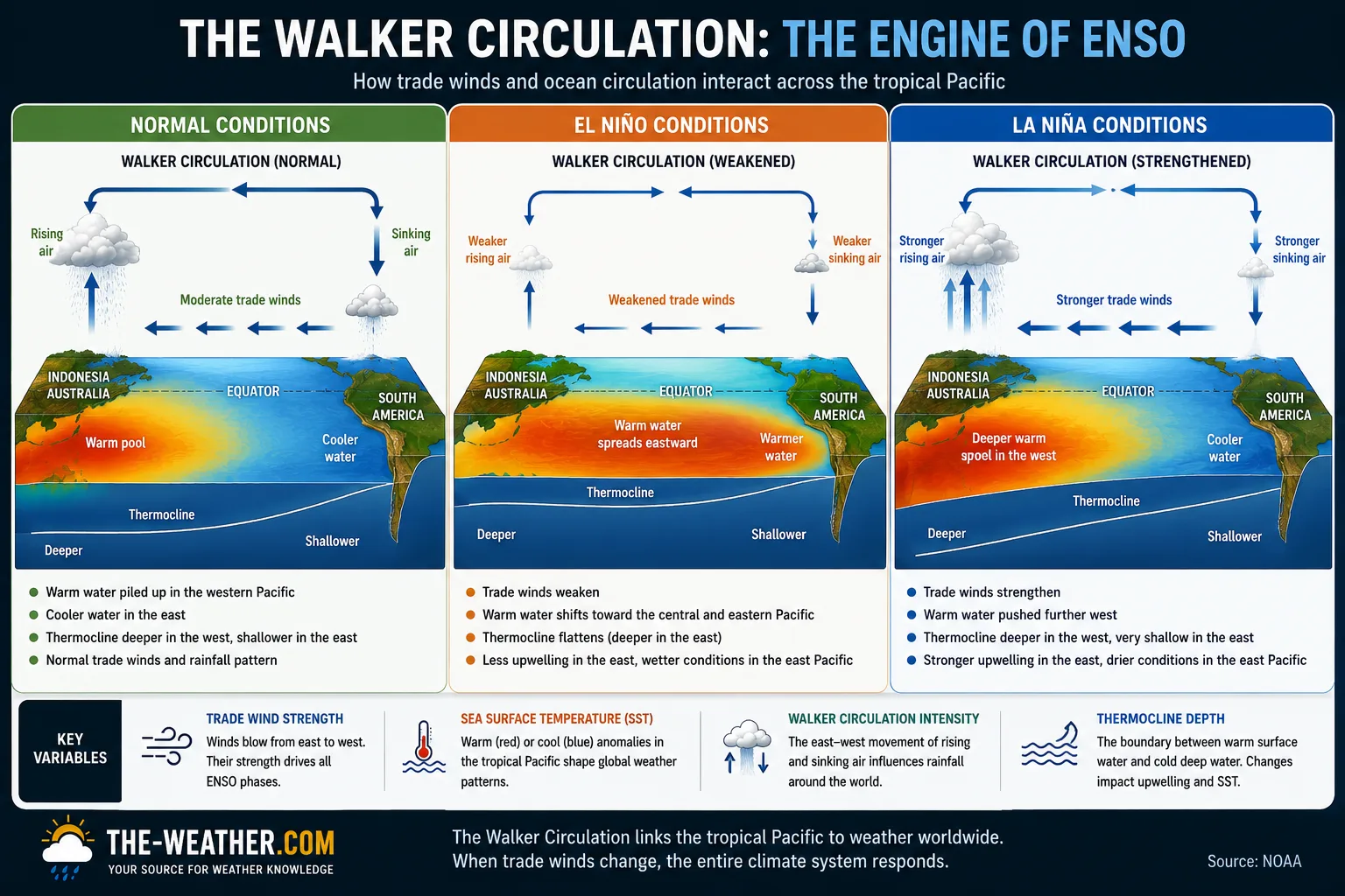
Walker Circulation under normal, El Niño, and La Niña conditions: trade wind strength is the variable that changes first in each transition.
The same physical mechanism, trade wind strength, produces three distinctly different Pacific states. The direction of change and the degree of departure from normal determine which phase develops.
- Warm pool contained in western Pacific
- Thermocline moderately tilted
- Normal cold upwelling in east
- Walker Circulation at standard strength
- Warm water spreads east across Pacific
- Thermocline deepens in east
- Cold upwelling suppressed
- Walker Circulation weakens
- Warm water pushed further west
- Thermocline shallows in east
- Enhanced cold upwelling
- Walker Circulation intensifies
How Trade Wind Weakening Produces El Niño
The causal chain from sustained trade wind weakening to full El Niño development involves several steps, each reinforcing the next through the Bjerknes feedback loop. Importantly, brief or isolated weakening, common during certain MJO phases, does not reliably produce El Niño. It is sustained weakening over weeks to months that initiates the chain.
| Step | What happens | Timescale |
|---|---|---|
| Trade winds weaken: sustained | Sustained weakening over weeks to months is the trigger. Short-lived MJO-driven bursts are common but do not reliably initiate El Niño without a favourable background state | Days to weeks |
| Warm water moves east | Kelvin waves carry warm water eastward along the equatorial Pacific | 2–3 months |
| Thermocline deepens in east | Cold upwelling suppressed off South America as thermocline drops | 1–2 months after Kelvin wave arrival |
| Eastern Pacific warms | Sea surface temperatures rise: Niño 3.4 index climbs toward +0.5°C | 3–6 months after initial trigger |
| Bjerknes feedback activates | Warmer east reduces pressure gradient, further weakening trade winds | Ongoing, amplifies over months |
| Walker Circulation weakens | Rainfall shifts eastward, atmospheric circulation reorganises globally | Full expression over 6–12 months |
The initial weakening can come from several sources. The Madden-Julian Oscillation, a 30 to 60 day tropical weather pattern, can produce westerly wind bursts over the western Pacific that temporarily reverse the trade winds. Seasonal forcing also plays a role: the trade winds are naturally slightly weaker in Northern Hemisphere spring, which is why most El Niño events develop during March to June. And random atmospheric variability can sometimes provide enough of an initial push to start the process.
How Trade Wind Strengthening Produces La Niña
La Niña develops through the same mechanism as El Niño, driven by trade wind strength, but in the opposite direction. When trade winds strengthen beyond their climatological average, they push warm surface water further west than normal. The thermocline in the eastern Pacific rises, bringing cold deep water closer to the surface, and enhanced upwelling cools the eastern and central Pacific below average.
| Step | What happens | Timescale |
|---|---|---|
| Trade winds strengthen | Often follows El Niño rebound, but can develop from neutral conditions | Days to weeks |
| Warm water pushed further west | Western Pacific warm pool deepens and expands beyond normal | Weeks to months |
| Upwelling Kelvin waves travel east | Waves shallow the thermocline in the eastern Pacific | 2–3 months |
| Enhanced cold upwelling | Cold nutrient-rich water rises to the surface off South America | 1–2 months after wave arrival |
| Eastern Pacific cools | Niño 3.4 index falls toward -0.5°C threshold | 3–6 months after initial trigger |
| Walker Circulation intensifies | Stronger east-west temperature gradient reinforces the trade winds: self-sustaining loop | Ongoing, why La Niña lasts longer |
The Walker Circulation: The Atmospheric Loop Trade Winds Drive
The Walker Circulation is the large-scale atmospheric loop that circulates air east to west across the tropical Pacific. It was named after Gilbert Walker, who identified the underlying pressure pattern (the Southern Oscillation) in the early 20th century, though Bjerknes was the first to describe its role in ENSO in 1969.
Under normal conditions the Walker Circulation operates as follows:
- Rising branch: Warm moist air rises vigorously over the western Pacific warm pool near Indonesia and Australia. This rising air releases latent heat as it condenses into clouds and rainfall: the heaviest rainfall on Earth occurs here during normal and La Niña conditions.
- Upper-level eastward flow: The rising air spreads eastward at high altitude (near the tropopause), flowing toward the cooler eastern Pacific.
- Sinking branch: The air descends over the cooler eastern Pacific near South America. This sinking suppresses cloud formation and contributes to the arid coastal climate of Peru and Ecuador under normal and El Niño conditions.
- Surface return flow: The air flows back westward near the surface: these are the trade winds themselves. The circulation is a closed loop driven by the temperature contrast between the warm west and cool east.
During El Niño, as the warm pool spreads east and the temperature contrast weakens, the Walker Circulation slows. During severe El Niño events it can partially reverse. During La Niña, the stronger temperature contrast drives a more vigorous circulation: stronger rising air, stronger trade winds, stronger everything in the loop.
Related Topics in the ENSO Science Cluster
Frequently Asked Questions
How do trade winds cause El Niño?
When trade winds weaken in a sustained way over weeks to months, the warm water they normally push westward sloshes back eastward across the Pacific via Kelvin waves. This raises sea surface temperatures in the central and eastern Pacific, shifts rainfall eastward, and weakens the Walker Circulation. Short-lived weakening events, often driven by the Madden-Julian Oscillation, are common and do not always lead to El Niño. It is the sustained departure that initiates the full development chain.
What are trade winds?
Trade winds are the persistent surface winds that blow eastward to westward across the tropical Pacific, Atlantic, and Indian Oceans between roughly 30°N and 30°S. They form because of the pressure gradient between subtropical high-pressure zones and the equatorial low, deflected westward by the Coriolis effect. They are the primary driver of tropical Pacific Ocean circulation.
What happens to trade winds during La Niña?
During La Niña, trade winds strengthen beyond their normal intensity. Stronger westward winds push warm surface water further into the western Pacific, expose cooler water through enhanced upwelling in the east, and intensify the Walker Circulation. This creates the cool sea surface temperatures and shifted rainfall patterns that define La Niña.
Why do trade winds weaken during El Niño?
Trade winds are driven by the pressure difference between the subtropical highs in the east and the low-pressure zone over the warm western Pacific. When warm water begins to spread east, and this spreading is sustained rather than brief, the pressure gradient weakens, reducing the force driving the trade winds. The Bjerknes feedback then amplifies this: weaker sustained winds allow more warm water to move east, which further reduces the gradient, further weakening the winds in a self-reinforcing loop.
Walker Circulation history, all three phases, measurement indices, MJO, and global teleconnections.
Sources
- NOAA Climate.gov: Trade winds, Walker Circulation, and ENSO mechanism
- WMO: ENSO and trade wind reference
- Bjerknes, J. (1969): "Atmospheric teleconnections from the equatorial Pacific": Monthly Weather Review. Original Walker Circulation and ENSO coupling paper.
No manufacturer compensation received. Science sourced from NOAA, WMO, and peer-reviewed literature.

Lena Thornton
Weather Station Analyst & CWOP Contributor. Lena researches atmospheric science and ENSO dynamics, translating complex ocean-atmosphere mechanisms into accessible explanations grounded in official sources. Published July 2026.