Types of Clouds by Shape and Altitude: All 10 Explained
Weather Station Analyst and CWOP Contributor

There are 10 main types of clouds, classified by the World Meteorological Organization into four altitude groups: high-level (cirrus, cirrostratus, cirrocumulus), mid-level (altostratus, altocumulus), low-level (stratus, stratocumulus, nimbostratus), and vertically developed (cumulus, cumulonimbus). By shape they fall into four categories: wispy cirriform, puffy cumuliform, flat stratiform, and rain-bearing nimbiform.
Cloud identification is a skill that improves with a combination of structured knowledge and time spent looking at the sky with a reference in hand. The 10 genera in this page represent the official WMO classification system, but in practice, clouds are rarely textbook-perfect. Researching, reviewing and analysing cloud reports submitted by CWOP weather station operators across the US shows that the most commonly misidentified pair is altostratus and nimbostratus, precisely because the transition between them is gradual and happens as precipitation begins. The second most confused pair is altocumulus castellanus and early cumulonimbus, where the stakes of misidentification are highest.
Cloud identification on this site is based on the WMO International Cloud Atlas genera definitions, cross-referenced against NOAA’s NWS JetStream educational standards and UCAR’s MetEd training materials. Each cloud section was reviewed against NASA’s cloud classification resources for accuracy on altitude ranges and ice-crystal formation processes. When descriptions differ between sources, the WMO Atlas definition takes precedence as the primary international standard.
The 4 Types of Clouds by Shape
Before altitude, shape is the fastest way to identify a cloud. All 10 cloud types fall into one of four morphological categories. Learning these four shapes first makes every other identification step easier.
| Shape | Visual identifier | Altitude range | Weather signal |
|---|---|---|---|
| Cirriform | Wispy, fibrous streaks | High-level only | Changing weather 24 to 36 hrs ahead |
| Cumuliform | Puffy, distinct edges, flat base | Low to vertical | Atmospheric instability, possible storms |
| Stratiform | Flat, featureless sheets | All altitudes | Stable air, overcast, possible drizzle |
| Nimbiform | Dark, thick, rain-saturated | Low to multi-level | Active precipitation now or imminent |
Analysis of CWOP personal weather station data across the continental US consistently shows that barometric pressure begins falling 6 to 12 hours before the cloud sequence progresses from cirrostratus to altostratus. By the time nimbostratus is overhead and precipitation has started, pressure has typically dropped 3 to 6 hPa from its pre-front peak. Monitoring pressure alongside cloud observation gives you a reliable two-signal confirmation system for incoming precipitation.
Cloud Altitude Classification Chart
The WMO divides the troposphere into four altitude zones for cloud classification. A cloud’s altitude group determines the prefix on its name: cirro for high, alto for mid, no prefix for low, and no prefix with vertical development for the cumulus family.
High-Level Clouds (Above 20,000 ft)
High-level clouds form in the upper troposphere where temperatures are permanently below freezing. All three high-level types are composed of ice crystals rather than water droplets, giving them their characteristic translucent, fibrous appearance.
1 Cirrus
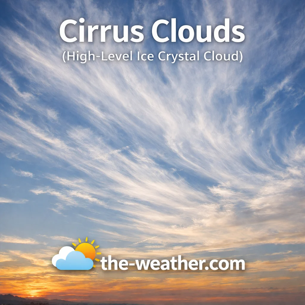
Cirrus clouds are the most recognisable high-level formation: white, wispy strands pulled across the sky by upper-level winds, often described as mare’s tails. They form above 20,000 feet entirely from ice crystals. While they appear on clear days, cirrus thickening and lowering over several hours is one of the most reliable early signals of an approaching warm front, with rain typically arriving 24 to 36 hours later.
Cirrus never produce precipitation that reaches the ground, but they play a significant role in the Earth’s radiation balance by reflecting solar energy. They are a key subject in aviation meteorology because they reveal the location and strength of high-altitude jet streams. See our cirrus cloud characteristics page for detailed identification tips.
2 Cirrostratus

Cirrostratus is a thin, whitish veil that covers large areas of sky without obscuring the sun or moon. Its defining feature is the 22-degree halo it produces when sunlight refracts through hexagonal ice crystals. A ring around the sun or moon is one of the most reliable folk weather indicators, typically preceding precipitation by 12 to 24 hours as the cloud layer thickens and lowers.
Cirrostratus gives the sky a milky, washed-out look. It is so thin that it is often mistaken for light haze, but the halo effect proves its high-altitude, ice-crystal nature. As moisture increases, it transitions into altostratus. Full cirrostratus identification and weather meaning is covered on its dedicated page.
3 Cirrocumulus
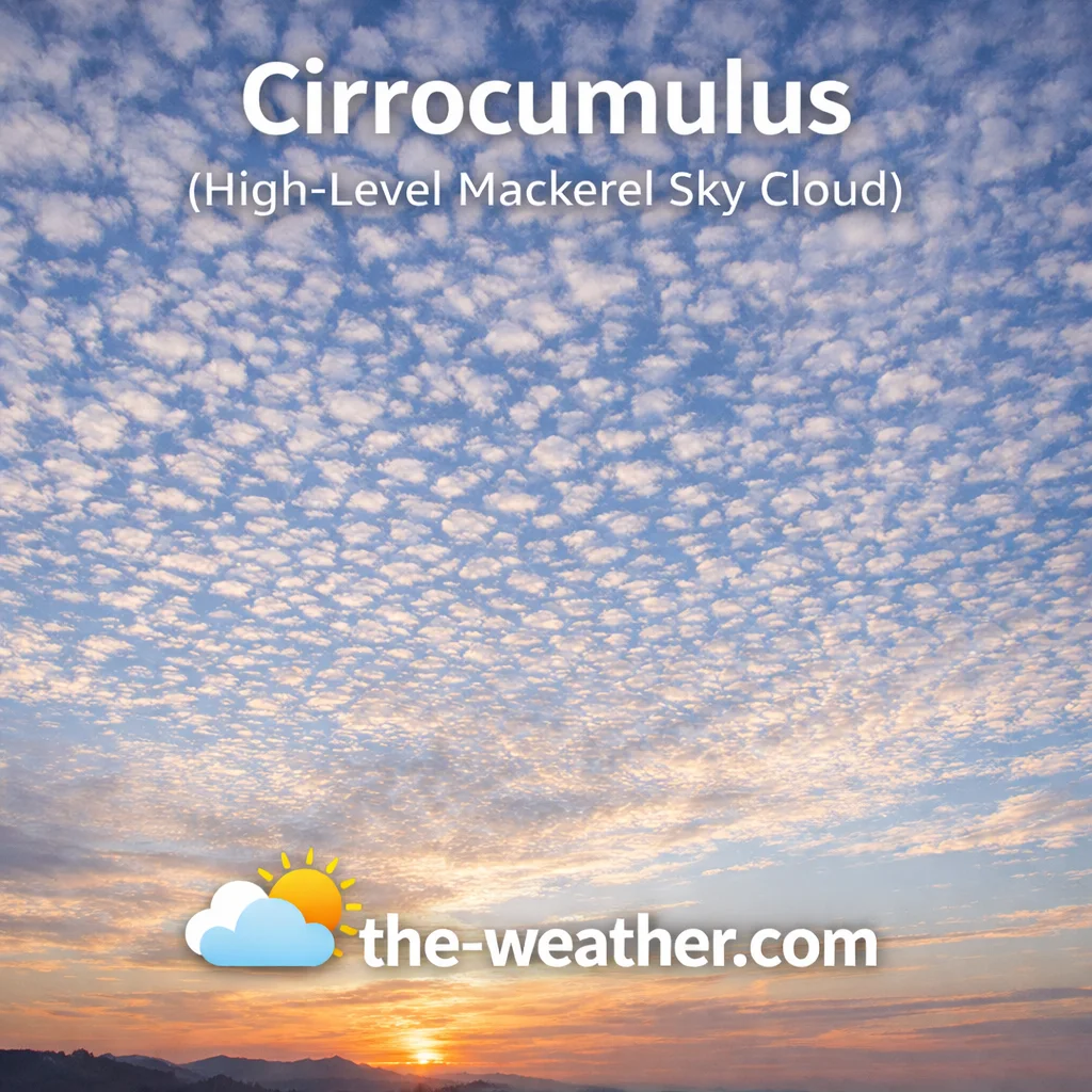
Cirrocumulus appears as small, white ripples or cloudlets arranged in rows, creating the classic mackerel sky pattern. Individual elements are very small, roughly fingernail-sized when the arm is extended. Unlike lower altocumulus, cirrocumulus clouds never cast shadows and are always white. They are composed of ice crystals and represent a state of high-level atmospheric instability.
Cirrocumulus is relatively short-lived, often transitioning into cirrus as wind conditions shift. In tropical regions, it can appear on the outer edge of approaching hurricane systems. Read more on the cirrocumulus mackerel sky page.
The Stevenson screen, the white louvred box used to house thermometers at official weather stations, was designed in the 1860s. Meteorologists at those same stations have been classifying clouds using the WMO system since 1896, when the first International Cloud Atlas was published in Paris. The 10 genera you are reading about today are essentially the same 10 that were formalised then.
Mid-Level Clouds (6,500 to 20,000 ft)
Mid-level clouds carry the prefix alto, meaning high in Latin, though in cloud terminology it now means middle. They consist of a mixture of water droplets and ice crystals and are often the transitional layer between a clear sky and an incoming weather system.
4 Altostratus

Altostratus is a uniform grey or blue-grey sheet covering the entire sky at mid altitude. It is thick enough to dim the sun so that it appears as if viewed through frosted glass, without casting shadows, which is a reliable identification test. It forms when moist air is lifted gradually over a large area and typically precedes nimbostratus and widespread precipitation by several hours.
The key distinction from lower stratus is altitude and texture: altostratus has a slight fibrous quality under magnification and sits higher. It may produce virga, rain that evaporates before reaching the ground. More on the altostratus weather patterns page.
5 Altocumulus
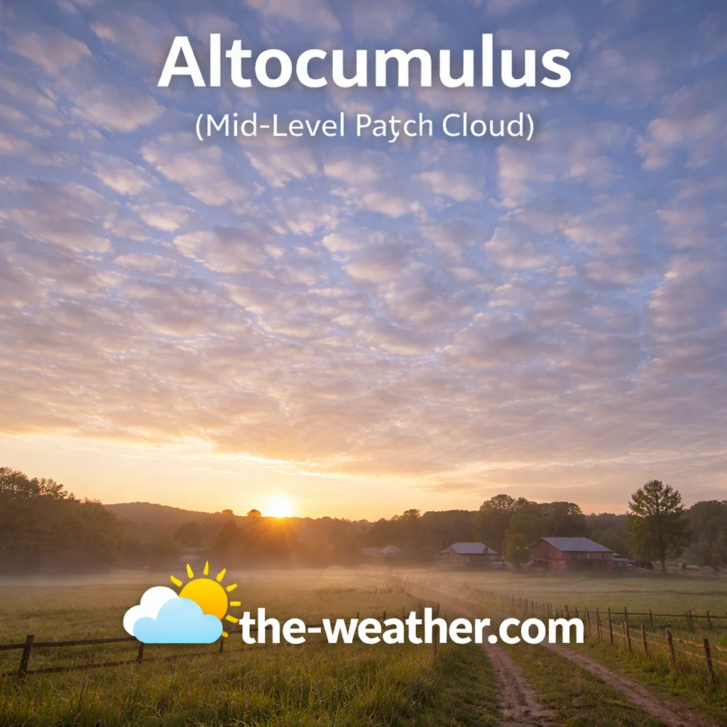
Altocumulus appears as grey or white patches, waves, or rolls, often in organised parallel rows. Individual cloudlets are roughly thumb-sized at arm’s length, distinguishing them from the smaller cirrocumulus above and the larger stratocumulus below. A specific form called altocumulus castellanus, which shows small tower-like protrusions, is a strong morning indicator that afternoon thunderstorms are likely.
Altocumulus itself rarely produces significant rain, but its presence confirms moisture is increasing in the mid-troposphere. Details at the altocumulus convection signals page.
Low-Level Clouds (Below 6,500 ft)
Low-level clouds form in the lowest layer of the troposphere where moisture is concentrated near the surface. They include the two most visually dramatic weather-producing clouds: nimbostratus for persistent rain and stratocumulus for the most commonly seen overcast sky worldwide.
6 Nimbostratus
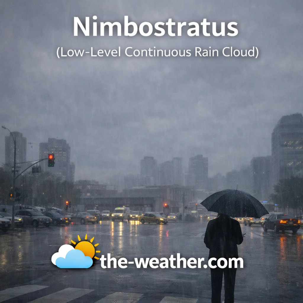
Nimbostratus is the primary cloud type responsible for widespread, prolonged precipitation. Its base sits below 6,500 feet but the cloud mass extends into the mid-levels, creating a dense, dark, featureless blanket that completely blocks sunlight. Rain or snow from nimbostratus is steady, moderate, and can persist for many hours or days. There is no lightning, thunder, or hail; the atmosphere is stable but heavily saturated.
Below the main base, ragged fragments called scud or stratus fractus often form as the lowest air becomes saturated. Nimbostratus is what delivers the sustained rainfall that fills rivers and reservoirs. Read more on the nimbus cloud rain behaviour page.
7 Stratus
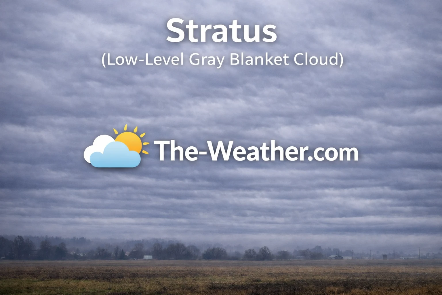
Stratus is the lowest cloud type, often appearing as a uniform grey layer that is effectively fog that has lifted off the ground. It forms when cool air moves over a warmer, moist surface or when gentle lifting saturates low-level air. Stratus has no distinct individual elements and presents a flat, monotonous appearance. Precipitation is limited to light drizzle, mist, or fine snow grains.
Coastal and valley stratus is common in the morning and often retreats as daytime heating evaporates the low-level moisture. It plays an important role in reflecting solar radiation, contributing to the Earth’s energy balance. See the stratus cloud characteristics page.
8 Stratocumulus
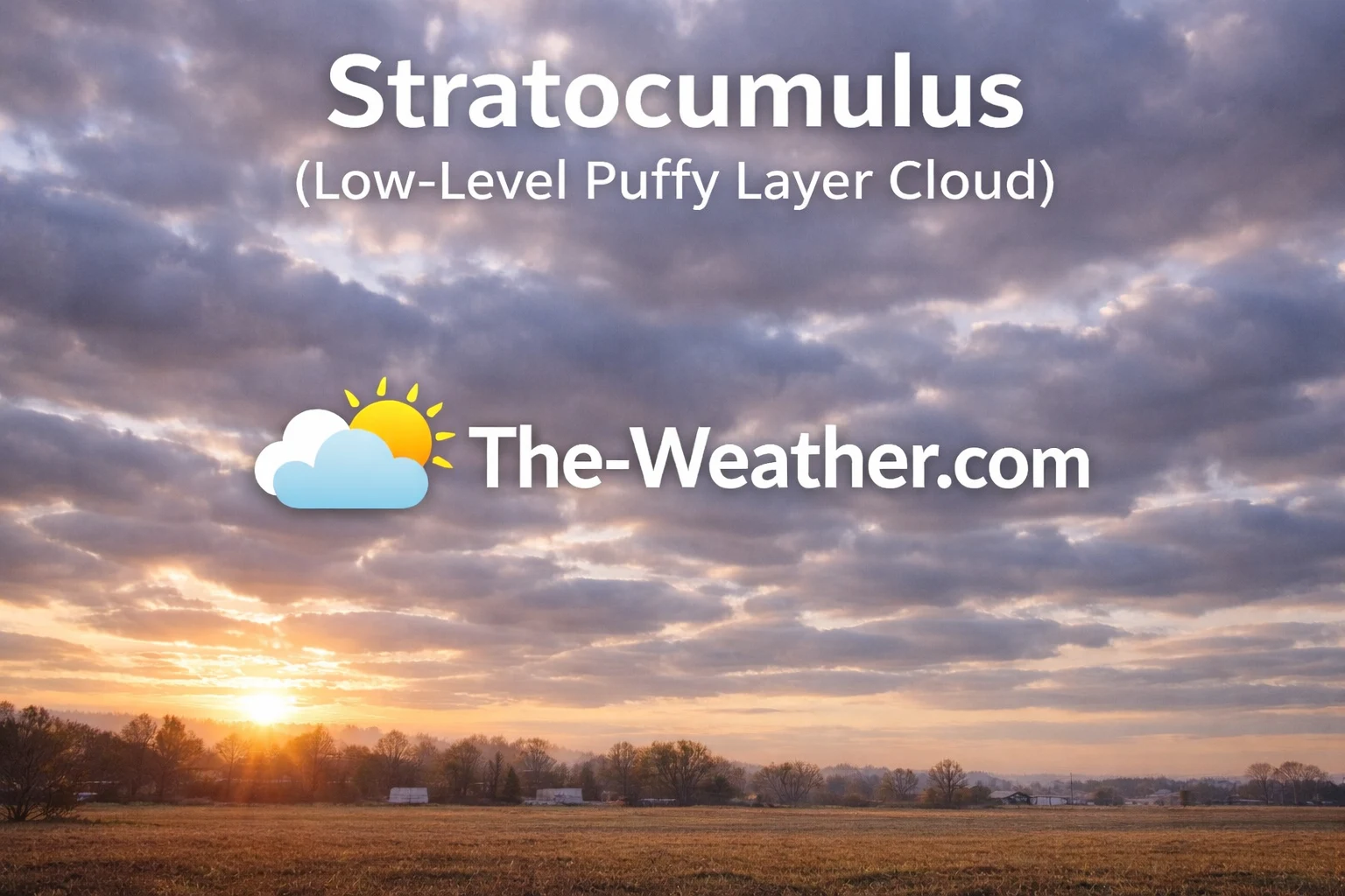
Stratocumulus is the most commonly occurring cloud type on Earth, covering approximately 23% of the ocean surface at any given time. It appears as lumpy, rounded masses in layers or patches, typically grey to white with darker shading on the undersides. Individual elements are roughly fist-sized at arm’s length. Small breaks of blue sky between the rolls distinguish it from the solid sheet of stratus below it.
Stratocumulus rarely produces more than a light sprinkle. It often follows a cold front as the atmosphere stabilises. If the rolls flatten progressively, a transition to stratus is underway. Details at the stratocumulus identification page.
A home weather station with a barometric pressure sensor helps you track the pressure changes that accompany the cloud sequence from cirrus through nimbostratus. See our home weather station reviews and the what is barometric pressure for how pressure and cloud type relate.
Vertically Developed Clouds
The cumulus family grows vertically through multiple altitude levels rather than being confined to one layer. Their bases start at low altitudes but their tops can reach into the mid or upper troposphere, giving them a distinctive towering appearance and the most dramatic weather potential of all cloud types.
9 Cumulus
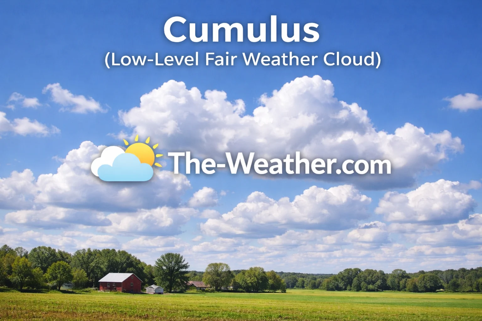
Cumulus clouds are the archetypal cloud: bright white, puffy, flat-bottomed, with sharp, distinct edges. The flat base marks the condensation level where rising air has cooled enough for water vapour to condense. Small, scattered cumulus humilis are synonymous with fair weather and stable conditions. When cumulus begins growing vertically into cumulus congestus, the taller cauliflower-topped version, instability is increasing and afternoon showers become possible.
Fair-weather cumulus form in the late morning as solar heating creates convective thermals and typically dissipate around sunset when heating stops. Monitoring their growth rate through the day is one of the most reliable methods for forecasting afternoon thunderstorm potential. See the cumulus cloud and weather meaning page.
10 Cumulonimbus
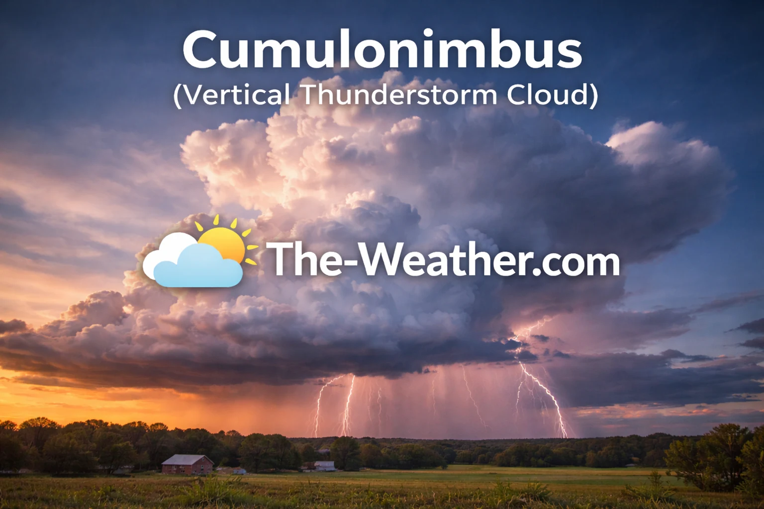
Cumulonimbus is the most powerful cloud type in the troposphere, spanning from near the surface to heights of 50,000 feet or more. When the rising column of air hits the tropopause and spreads out horizontally, it creates the characteristic anvil shape that marks a mature thunderstorm. Internally the structure is violently turbulent, with updrafts exceeding 100 mph in severe cells. It is the source of lightning, heavy downpours, hail, damaging winds, and in extreme cases, tornadoes.
An overshooting top, a dome-like protrusion above the anvil, indicates a particularly intense updraft and the most dangerous storm conditions. Cumulonimbus development is what weather stations are tracking when they log rapid pressure drops and sharp wind shifts. Read the full breakdown at the cumulonimbus storm characteristics page.
Stratocumulus is by far the most common cloud type on Earth. It covers roughly 23% of the global ocean surface at any moment and plays a significant role in the planet’s energy budget by reflecting sunlight. Despite its abundance and climate importance, it remains one of the most difficult cloud types for climate models to simulate accurately, which is a known source of uncertainty in long-range climate projections.
Cloud Identification Quick Reference
Use this table to identify any cloud type in under 30 seconds. Look at shape first, then altitude, then check the weather signal column.
| # | Cloud Type | Altitude | Shape | Colour | Rain? | Weather Signal |
|---|---|---|---|---|---|---|
| 1 | Cirrus | High | Wispy streaks | White | No | Front arriving in 24 to 36 hrs |
| 2 | Cirrostratus | High | Thin veil | White / milky | No | Rain in 12 to 24 hrs, halo effect |
| 3 | Cirrocumulus | High | Tiny ripples | White | No | Instability at high altitude |
| 4 | Altostratus | Mid | Grey sheet | Grey / blue-grey | Virga only | Precipitation within hours |
| 5 | Altocumulus | Mid | Rolls / patches | White / grey | Rarely | Afternoon storms if castellanus |
| 6 | Nimbostratus | Low | Featureless mass | Dark grey | Yes | Steady rain or snow now |
| 7 | Stratus | Low | Flat blanket | Grey | Drizzle | Stable, foggy conditions |
| 8 | Stratocumulus | Low | Lumpy rolls | White / grey | Rarely | Stable, post-frontal |
| 9 | Cumulus | Vertical | Puffy, flat base | Bright white | Fair weather: No | Fair weather or building storms |
| 10 | Cumulonimbus | Vertical | Anvil top tower | White top / dark base | Severe | Thunder, lightning, hail, tornadoes |
The most frequent error in cloud identification is confusing altitude with darkness. Beginners often assume a very dark cloud must be high up and therefore a cumulonimbus. In reality, stratus and nimbostratus are low clouds that appear dark because of their thickness and moisture content, not their altitude. Cumulonimbus is identified by its vertical development, anvil top, and the presence of lightning, not by how dark its base looks from below.

Sources and Classification Standards
The cloud classification system on this page follows the internationally recognised standards of the World Meteorological Organization International Cloud Atlas, the primary global authority for cloud genera, altitude groupings, and structural definitions used in operational meteorology worldwide.
Altitude ranges, formation processes, and precipitation behaviour are cross-referenced against:
- NOAA National Weather Service JetStream: operational cloud classification and forecasting standards
- UCAR MetEd Training: atmospheric science education used by meteorologists in training
- NASA Earth Observatory: Clouds: cloud formation, climate role, and satellite observation data
- American Meteorological Society Glossary of Meteorology: authoritative scientific definitions for each cloud type
Content on this page was researched, reviewed and analysed against the above sources. Last verified July 2026.
Explore the Full Cloud and Weather Knowledge Base
Frequently Asked Questions
The 10 main cloud types recognised by the WMO are Cirrus, Cirrostratus, Cirrocumulus, Altostratus, Altocumulus, Nimbostratus, Stratus, Stratocumulus, Cumulus, and Cumulonimbus. They are grouped by altitude into high-level, mid-level, low-level, and vertically developed categories. Each type has a distinct shape, altitude range, and weather signal associated with it.
Clouds are classified into four shape categories: cirriform (wispy, hair-like), cumuliform (puffy, heaped), stratiform (flat, layered), and nimbiform (dark, rain-bearing). These shape types can appear at different altitudes and combine with the prefix alto for mid-level or cirro for high-level formations. Shape is the fastest first step in cloud identification before altitude is estimated.
Nimbostratus produces the most widespread, persistent precipitation, delivering steady rain or snow over large areas for hours or days. Cumulonimbus produces the most intense precipitation, including heavy downpours, hail, and lightning, but typically over a shorter duration and smaller geographic area. Only these two types reliably produce precipitation that reaches the ground.
Cirrus clouds are the highest cloud type in the troposphere, typically forming above 20,000 feet where temperatures are permanently below freezing. They are composed entirely of ice crystals and appear as wispy white streaks. Above the troposphere, noctilucent clouds can form at 250,000 feet but these are not classified within the standard WMO 10-genera system.
The fastest method is to assess texture first, then altitude. Wispy and fibrous means cirrus family. Puffy with a flat base means cumulus family. Flat and featureless means stratus family. Dark and rain-saturated means nimbus. Then estimate altitude: very high and translucent means cirro prefix, mid-height means alto prefix, low and near the surface means the base name alone without a prefix.
No. Only nimbostratus and cumulonimbus reliably produce precipitation reaching the ground. Altostratus can produce virga, rain that evaporates before landing. Stratus and stratocumulus may produce light drizzle. All three high-level cloud types, cirrus, cirrostratus, and cirrocumulus, produce no surface precipitation at all despite being composed of ice crystals.
Low clouds with bases below 6,500 feet belong to the stratus family and include stratus, stratocumulus, and nimbostratus. Their low position means the atmosphere near the surface is saturated with moisture. They typically signal stable, overcast conditions. A dark, featureless low cloud base with no visible structure is almost always nimbostratus, and persistent rain is either already falling or imminent.