
As an Amazon Associate, I earn from qualifying purchases.
In this article 9 sections
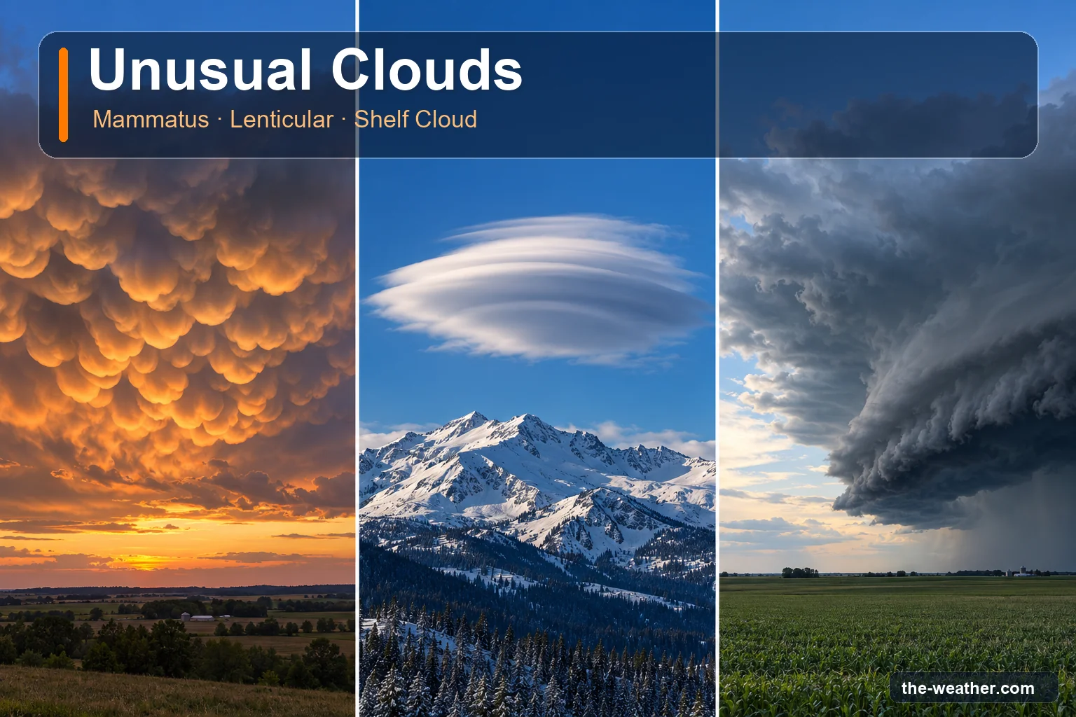
Most clouds are polite. They drift by, look like a sheep or a dragon for a minute, and move on. But now and then the sky puts on something that makes you grab your phone: pouches hanging from a storm, a flying saucer parked over a mountain, or a dark wall rolling in over the fields. These three have names, and one of them is also a clear signal to go inside.
Short answer: mammatus are pouches hanging under a cloud, most often under the anvil of a thunderstorm, and they show sinking air. A lenticular cloud is a smooth lens or almond shape that forms most often over or downwind of mountains. A shelf cloud is a low, wedge-shaped arch at the front of a thunderstorm that marks the gust front, the leading edge of gusty winds from the storm. Of the three, the shelf cloud is the one to act on: head indoors (NWS Spotter Glossary).
Editorial Research
- Written by
- Lena Thornton, Weather Station Analyst & CWOP Contributor
- Based on
- The WMO International Cloud Atlas (mamma, lenticularis, arcus), the National Weather Service Spotter Glossary and forecast glossary, NWS Louisville, the Geophysical Institute of the University of Alaska and the NWS aviation bulletin "The Front" (April 2013)
- Research last verified
- October 19, 2026
The Three at a Glance
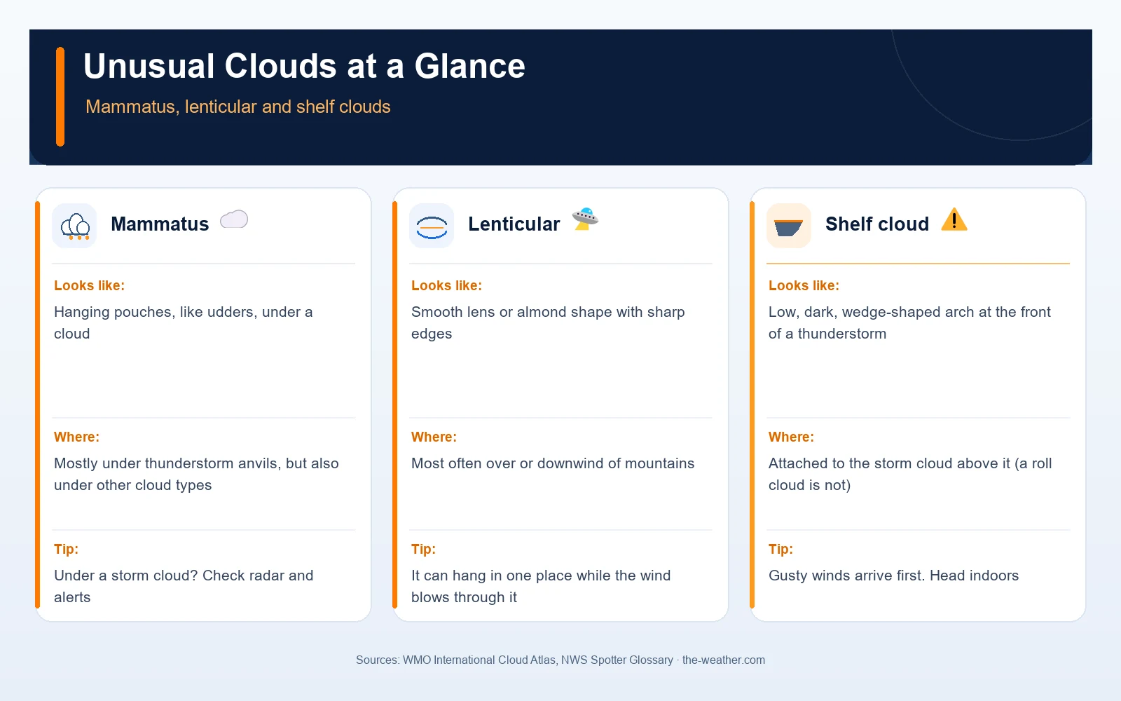
A handy thing to know first: in the official cloud atlas, none of these three is a separate cloud type. They are features or shapes of the ten main cloud types you already know from our types of clouds guide:
- Mammatus (officially mamma) is a supplementary feature: something extra on a cloud.
- Lenticular (officially lenticularis) is a species: a shape that some cloud types can take.
- Shelf cloud is a kind of arcus, also a supplementary feature.
So when someone asks "what kind of cloud is that?", the precise answer is often two words: for example "altocumulus lenticularis", a lens-shaped altocumulus.
Mammatus: Pouches Under the Storm
The World Meteorological Organization (WMO) describes mammatus as "hanging protuberances, like udders, on the under surface of a cloud." Once you have seen them, you do not forget them. Especially at sunset, when low light turns every pouch orange.
Where you see them
The WMO says mammatus occurs mostly with cirrus, cirrocumulus, altocumulus, altostratus, stratocumulus and cumulonimbus. The famous ones, though, hang under thunderstorms: the NWS office in Louisville notes that they are usually found on the anvil portions of thunderstorms (cumulonimbus clouds).
How they form
The NWS Louisville explanation goes like this. In a thunderstorm, an updraft carries precipitation upward. Some of it, ice crystals and water droplets, spreads out and forms the anvil. Those particles are sometimes heavier than the surrounding air and begin to sink. That sinking, together with evaporation, creates the pouch shapes. In short: mammatus show sinking air.
What it means for you
Mammatus are a sign, not a storm of their own: what matters is the cloud they hang under. If that is a thunderstorm anvil, the thunderstorm is nearby. That is the moment to check the radar and any warnings for your area. Our guide on how to read weather radar helps you see where the storm is heading.
Lenticular Clouds: The Flying Saucers
The WMO definition of lenticularis: clouds "having the shape of lenses or almonds, often very elongated and usually with well-defined outlines." They occasionally show irisation, a soft rainbow shimmer along the edges. It is not hard to see why they are blamed for many a UFO report.
Where you see them
According to the WMO, lenticular clouds appear most often in cloud formations of orographic origin, which means caused by mountains, but they can also occur where there are no big mountains. The term applies mainly to cirrocumulus, altocumulus and stratocumulus.
How they form
When moist air is pushed up over a mountain, it cools as it rises and the moisture condenses into a cloud. On the far side the air sinks and warms, and the droplets evaporate again. The Geophysical Institute of the University of Alaska puts it neatly: individual droplets move through the cloud with the wind, while the cloud as a whole stays fixed over the mountain. Downwind of a range the air can keep rising and sinking in mountain waves, a bit like water flowing over a rock in a stream. That is why the National Weather Service speaks of standing lenticular clouds.
What it means for you
On the ground, a lenticular cloud is mostly something to enjoy. For pilots it is a signal. The NWS aviation bulletin "The Front" (April 2013) lists cirrocumulus and altocumulus standing lenticular clouds among the clouds that alert pilots to mountain wave activity, and notes that mountain wave activity increases with strong winds across mountainous terrain. So a lenticular cloud is a hint that the air is moving in waves up there. It is a sign of wave motion, not a fixed measure of how strong the wind is.
Shelf Cloud: The Wall at the Front of a Storm
This is the one that looks the most dramatic, and it deserves that reputation. The NWS Spotter Glossary describes a shelf cloud as "a low, horizontal wedge-shaped arcus cloud, associated with a thunderstorm gust front." Rising cloud motion can often be seen in its leading edge, and its underside often looks turbulent, boiling and wind-torn.
The WMO describes arcus in general as a dense, horizontal roll with more or less tattered edges on the lower front part of certain clouds, which can look like "a dark, menacing arch." It occurs with cumulonimbus and, less often, with cumulus.
What it means for you
The shelf cloud sits on the gust front. The NWS defines that as the leading edge of gusty surface winds from thunderstorm downdrafts. In plain words: when the shelf cloud reaches you, a burst of wind comes with it, and the storm itself is right behind. Do not wait for the photo to be perfect. Take it from a safe place and head indoors. The NWS rule for thunderstorms is simple: when thunder roars, go indoors.
If you have a home weather station, look at your wind and temperature graphs afterwards. The NWS describes the passage of thunderstorm-cooled air (an outflow boundary) as marked by a wind shift and usually a drop in temperature, and the gust front brings gusty winds. Compare it with what you saw in the sky afterwards; it is a nice way to learn your own station's "storm signature".
Shelf Cloud or Roll Cloud?
They are easy to confuse. In the NWS glossaries, both are described as arcus clouds associated with a thunderstorm gust front, and the glossaries give one clear difference between them:
| Cloud | Shape | Attached to the storm? | How common |
|---|---|---|---|
| Shelf cloud | Low, horizontal wedge | Yes, attached to the base of the parent cloud above it | The one you usually see at the front of a storm |
| Roll cloud | Low, horizontal tube that seems to turn around a horizontal axis | No, detached from the storm's base | Rare |
Sources: NWS Spotter Glossary (shelf cloud) and NWS forecast glossary (roll cloud). The NWS also notes that a roll cloud should not be mistaken for a funnel cloud.
Which One Should Worry You?
| Cloud | What it tells you | What to do |
|---|---|---|
| Mammatus | Sinking air; under an anvil, a thunderstorm is nearby | Check radar and warnings |
| Lenticular | Air moving in waves over mountains; pilots read it as a mountain wave sign | Enjoy the view |
| Shelf cloud | The gust front: gusty winds arrive first, the thunderstorm right behind | Head indoors |
Want to read the rest of the sky as well? See reading the sky, how to tell if a storm is coming and our page on the grey rain blanket, nimbostratus.
Unusual Clouds FAQ
What do mammatus clouds mean?
They indicate sinking air and are usually found on the anvil of a thunderstorm (NWS Louisville). If you see them under a storm anvil, check radar and warnings for your area.
Why do lenticular clouds look like UFOs?
Because of their smooth lens or almond shape with sharp outlines (WMO), and because they can seem to hang in one place. They form where wind blowing over mountains sets the air moving in waves.
Is a shelf cloud dangerous?
It marks the gust front of a thunderstorm: the leading edge of gusty winds from the storm's downdrafts (NWS). The wind arrives with it and the storm follows, so head indoors.
What is the difference between a shelf cloud and a roll cloud?
A shelf cloud is attached to the base of the storm cloud above it; a roll cloud is a detached, tube-shaped cloud that seems to roll around a horizontal axis. Roll clouds are rare (NWS glossaries).
Are these three separate cloud types?
No. In the WMO International Cloud Atlas, mamma and arcus are supplementary features and lenticularis is a species of existing cloud types such as altocumulus.
Update Log
- October 19, 2026: Page published after an editorial review (lenticular and roll cloud wording made more careful, infographic description improved). Definitions checked against the WMO International Cloud Atlas and the National Weather Service glossaries; formation of mammatus from NWS Louisville; mountain wave note from the NWS bulletin "The Front" (April 2013).
Sources
- WMO International Cloud Atlas: Mamma
- WMO International Cloud Atlas: Lenticularis
- WMO International Cloud Atlas: Arcus
- National Weather Service Spotter Glossary: Shelf cloud and Gust front
- National Weather Service glossary: Roll cloud
- National Weather Service Spotter Glossary: Outflow boundary
- Geophysical Institute, University of Alaska Fairbanks: Flying Saucer Clouds
- National Weather Service Louisville: Thunderstorm photo album (mammatus)
- National Weather Service: "The Front", April 2013 (mountain waves, PDF)
- National Weather Service: Lightning safety
See also: 10 Types of Clouds · Cloud Classification · Cumulonimbus · Nimbostratus