Cumulonimbus Cloud Identification: Characteristics and Storm Signals
Master cumulonimbus cloud identification. A scientific look at vertical growth, atmospheric instability, and severe weather patterns from a meteorological perspective.The cumulonimbus cloud is the most formidable member of the vertical development group, spanning from the lower atmosphere to the top of the troposphere. Known for producing severe weather, these clouds are essential to study for meteorological safety and storm tracking. This guide explores their unique structure, from the dark base to the iconic anvil top.
Physical Characteristics and Vertical Growth
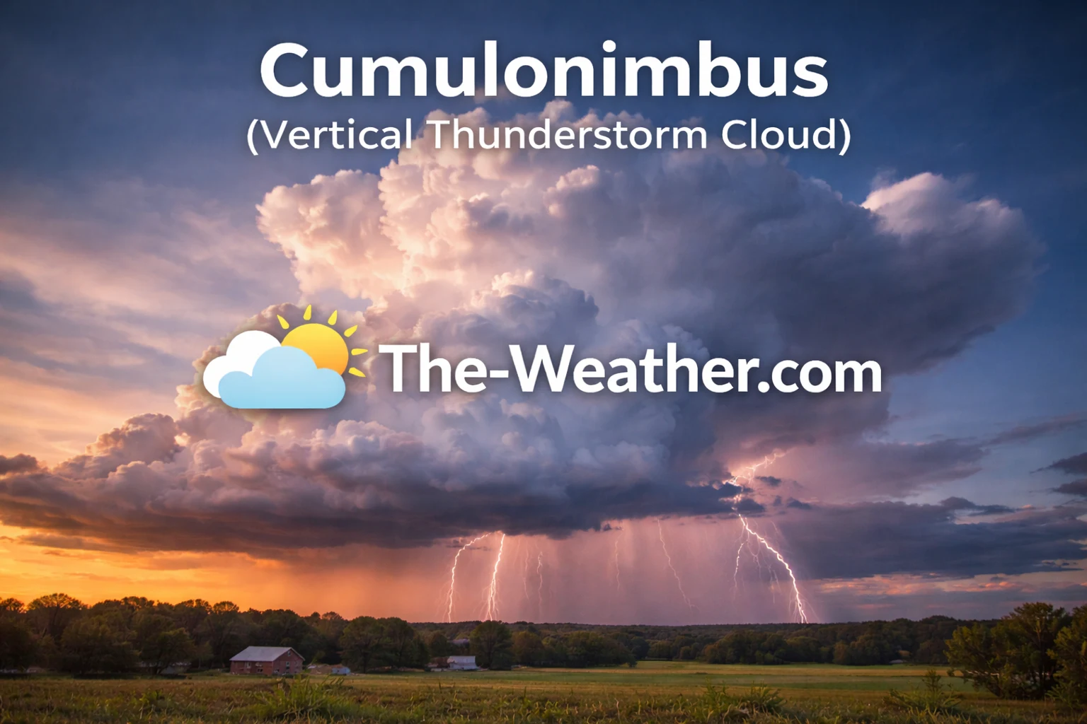
A mature cumulonimbus exhibiting massive vertical growth.
The primary defining feature of the cumulonimbus cloud is its immense vertical scale. Unlike the fair-weather cumulus cloud, which remains relatively small and scattered, the cumulonimbus is a towering giant that consumes the entire depth of the local atmosphere. Its base typically sits quite low, often between 2,000 to 5,000 feet, while its summit can reach altitudes exceeding 50,000 feet in tropical regions. This growth is fueled by powerful convective updrafts that carry moisture rapidly upward.
As the cloud matures, it undergoes a transformation known as glaciation. The water droplets at the top of the tower freeze into ice crystals, giving the summit a fibrous or wispy texture similar to cirrus cloud formations. When the rising air hits the tropopause—the boundary where the atmosphere stops cooling—it is forced to spread out horizontally. This creates the “incus” or anvil top, a classic visual signal that a thunderstorm is fully developed and dangerous. Identifying this anvil is the most reliable way to distinguish a mature storm from a growing cumulus congestus.
Atmospheric Instability and Formation
The formation of a cumulonimbus requires three specific ingredients: moisture, instability, and a lifting mechanism. In many cases, these clouds begin as small cumulus formations that benefit from intense solar heating. As the ground warms, air parcels rise; if the atmosphere is unstable, these parcels continue to ascend, cooling and condensing into massive vertical structures. This process is a key part of the broader types of clouds classification system, where vertical clouds represent the highest energy states.
Inside the cloud, the environment is incredibly turbulent. Rapid updrafts carry moisture to the freezing levels, while simultaneous downdrafts bring cold air and precipitation toward the surface. This internal cycling is responsible for the generation of static electricity, which eventually results in lightning. Furthermore, the strong vertical motion allows ice crystals to grow into hailstones by repeatedly cycling them through the freezing and melting layers of the cloud. The darker the base of the cumulonimbus appears to an observer on the ground, the more moisture and vertical depth the cloud possesses, indicating a higher potential for heavy rainfall.
Recommended Books for Cloud Identification

If you want to go deeper than basic cloud charts, a dedicated cloud identification field guide can dramatically improve your understanding of altitude layers, cloud genera, and weather patterns.
Detailed photography and structured classifications make it easier to distinguish between similar formations such as altostratus vs. nimbus clouds. Many meteorology students rely on these guides for accurate sky observation.
View Cloud Identification BooksDisclosure: As an Amazon Associate, we may earn from qualifying purchases at no extra cost to you.
Weather Patterns and Storm Signals

Advanced weather tracking relies on accurate cloud identification.
The arrival of a cumulonimbus cloud is almost always a signal of impending severe weather. Unlike the steady, light precipitation of nimbus clouds, cumulonimbus events are characterized by their intensity and suddenness. They are the only clouds capable of producing lightning and thunder. Additionally, they are the primary source of heavy downpours that lead to flash flooding, as they can dump large volumes of water over a localized area in a very short amount of time.
In extreme environments, these vertical giants develop “overshooting tops,” where the updraft is so strong it punches through the anvil and into the lower stratosphere. This is a critical signal for severe thunderstorm warnings, as it often correlates with damaging wind gusts and potential tornado formation. For pilots and sailors, the cumulonimbus is the most dangerous obstacle in the sky, requiring wide detours to avoid the intense turbulence and icing conditions found within the cloud walls. Understanding these storm signals is a foundational skill for any weather enthusiast.
Common Questions (FAQ)
What is the main difference between cumulus and cumulonimbus?
Size and energy. A cumulus cloud is small and puffy with no precipitation. A cumulonimbus is a massive vertical tower that produces lightning and rain.
Why do cumulonimbus clouds have an anvil top?
The anvil forms because the rising air reaches the tropopause, where it can no longer rise. The air then spreads out horizontally, creating the shelf-like incus top.