
We may earn a commission when you buy through links on this page, at no extra cost to you. Learn more
In this article 13 sections
- Step 1: Find Your County and SAME Code
- Step 2: Frequencies to Try, by County
- Map: Where the Transmitters Stand
- Where the Official Sources Differ
- How to Set Up the Radio
- What the Six Digits of a SAME Code Mean
- What These Tables Cannot Tell You
- Record: Hurricane Isaias, October 9, 2026
- Still Need to Choose a Radio?
- Questions About Weather Radio on the Gulf Coast
- How We Put This Page Together
- Update Log
- Sources
If a hurricane or tropical storm warning is in effect for you right now: go to the official sources first. Check the National Hurricane Center, your local National Weather Service office and your county emergency management. If officials tell you to evacuate, go. Do not wait to buy or set up a radio.
A NOAA Weather Radio receives its broadcasts without the internet or the phone network, as long as the receiver has power and the transmitter is on the air. If your radio has SAME, enter the six-digit code for your county and check that the transmitter you tune to broadcasts alerts for that county. A radio without SAME may sound for warnings anywhere in the transmitter's coverage area. Follow your radio's manual, and do not choose a station on signal strength alone. This page gives the frequencies and the codes for twelve coastal counties from Mississippi to the Florida Panhandle, using the National Weather Service's own listings.
Short answer: look up your town in the first table to find your county and its six-digit SAME code. The second table shows the transmitters listed for that county. Confirm in the official NWS Station Search that the transmitter you choose carries your county, then test at home which one you receive clearly. The listings are a starting point, not a promise of reception: the official listings we compared differ for Bay and Walton counties and in how they describe the reach of the Dozier transmitter, and a transmitter can be off the air. Check the current status on the NWS outage page.
Editorial Research & Review
- Written by
- Lena Thornton, Weather Station Analyst & CWOP Contributor
- Based on
- The National Weather Service national NOAA Weather Radio county coverage listing, compared with the transmitter pages of the NWS offices in Mobile/Pensacola and Tallahassee. Town-to-county matches and county positions: U.S. Census Bureau. All read on October 9, 2026
- Hands-on testing
- Not performed by The-Weather.com. We did not test reception anywhere. The distances are our own straight-line calculation from official coordinates
- Research last verified
- October 9, 2026
Step 1: Find Your County and SAME Code
The SAME code belongs to the county, not to the town. Find your town here first.
| County | SAME code | Towns and communities in this county |
|---|---|---|
| Hancock, Mississippi | 028045 | Bay St. Louis, Waveland |
| Harrison, Mississippi | 028047 | Gulfport, Biloxi, Long Beach, Pass Christian, D'Iberville |
| Jackson, Mississippi | 028059 | Ocean Springs, Pascagoula, Gautier, Moss Point |
| Mobile, Alabama | 001097 | Mobile, Prichard, Saraland, Dauphin Island, Bayou La Batre |
| Baldwin, Alabama | 001003 | Gulf Shores, Orange Beach, Foley, Fairhope, Daphne, Spanish Fort, Bay Minette |
| Escambia, Florida | 012033 | Pensacola |
| Santa Rosa, Florida | 012113 | Gulf Breeze, Milton, Navarre, Pace |
| Okaloosa, Florida | 012091 | Fort Walton Beach, Destin, Niceville, Crestview |
| Walton, Florida | 012131 | Miramar Beach, DeFuniak Springs |
| Bay, Florida | 012005 | Panama City, Panama City Beach, Lynn Haven, Mexico Beach |
| Gulf, Florida | 012045 | Port St. Joe |
| Franklin, Florida | 012037 | Apalachicola, Carrabelle, Eastpoint |
Town-to-county matches checked against U.S. Census Bureau place and county boundaries on October 9, 2026 (42 towns and communities). A few places lie close to a county line: if you are unsure, your property tax bill or voter registration names your county.
Step 2: Frequencies to Try, by County
This table is a regional starting point. For one specific address, the National Weather Service has its own Station Search: enter a city, address or ZIP code and it shows the stations nearby, with the counties each one carries. Use it to confirm that the transmitter you pick really broadcasts your county's SAME code.
| County | SAME code | Transmitters in the national listing, nearest first (approximate straight-line distance to the county reference point) | Local NWS office |
|---|---|---|---|
| Hancock, Mississippi | 028045 |
| NWS New Orleans/Baton Rouge |
| Harrison, Mississippi | 028047 |
| NWS New Orleans/Baton Rouge |
| Jackson, Mississippi | 028059 |
| NWS New Orleans/Baton Rouge; NWS Mobile/Pensacola |
| Mobile, Alabama | 001097 |
| NWS Mobile/Pensacola |
| Baldwin, Alabama | 001003 |
| NWS Mobile/Pensacola |
| Escambia, Florida | 012033 |
| NWS Mobile/Pensacola |
| Santa Rosa, Florida | 012113 |
| NWS Mobile/Pensacola |
| Okaloosa, Florida | 012091 |
| NWS Mobile/Pensacola |
| Walton, Florida | 012131 |
| NWS Mobile/Pensacola; NWS Tallahassee |
| Bay, Florida | 012005 |
| NWS Tallahassee |
| Gulf, Florida | 012045 |
| NWS Tallahassee |
| Franklin, Florida | 012037 |
| NWS Tallahassee |
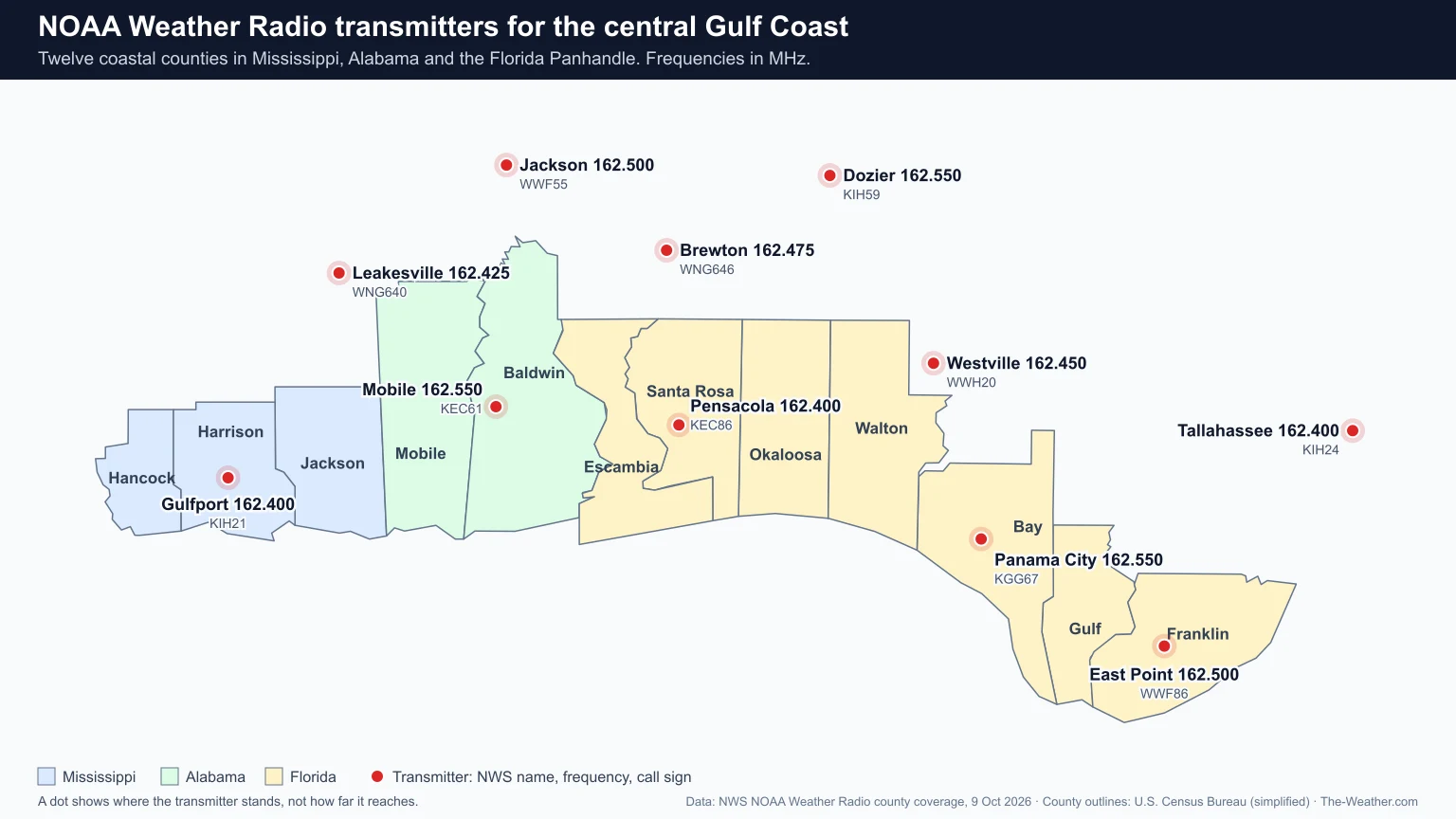
Source: National Weather Service, NOAA Weather Radio county coverage, read October 9, 2026, when all 11 transmitters were listed as "Normal". That is a snapshot: check the NWS outage page for today. Transmitter names are the ones the national listing uses. Distances are approximate straight lines from the transmitter to the U.S. Census Bureau's reference point for the county (a point inside the county, roughly its middle), rounded to 5 miles: your own distance will differ, and distance is only one of the things that decide reception.
Map: Where the Transmitters Stand
Where the Official Sources Differ
We compared the national county listing with the pages of the two local National Weather Service offices. Most rows match. Three things do not, and they are worth knowing before you rely on a single frequency:
- Bay County, Florida. The national listing names one transmitter, Panama City (162.550 MHz). The NWS Tallahassee page also lists Eastpoint (162.500 MHz) and Bethlehem (162.450 MHz) for Bay County.
- Walton County, Florida. The national listing names Dozier, Panama City and Westville. The NWS Tallahassee page lists Panama City and Bethlehem, and not Dozier. Westville and Bethlehem are the same transmitter: both sources give call sign WWH20 on 162.450 MHz.
- The Dozier transmitter. The national listing includes it for Santa Rosa (about 70 miles), Okaloosa (about 65 miles), Walton (about 70 miles). The NWS Mobile/Pensacola page describes Dozier as serving Andalusia and Troy in Alabama, well inland. On the coast it is the farthest of the listed transmitters, so try the nearer ones first.
When we read them: the national county listing on October 9, 2026; the NWS Tallahassee page on October 9, 2026; the NWS Mobile/Pensacola page on October 9, 2026. Neither local page shows a date of its own, so we cannot tell which source is more recent, and we do not know why they differ. We show the national listing in the table and the local differences beside it, as an open question rather than a settled one. In practice the advice is the same either way: look up your address in the Station Search, then test the transmitters it names.
How to Set Up the Radio
- Confirm which transmitters carry your county. Enter your city, address or ZIP code in the official NWS Station Search and note the stations that broadcast your county's SAME code. The National Weather Service warns against programming a radio for a louder or clearer station that is not the designated one for your county: you would not receive your alerts.
- Then test reception at home. Among the transmitters that carry your county, keep the one you hear most clearly. Hills, buildings and distance all matter, so the best choice can differ from one side of a county to the other.
- Enter the SAME code. With the code set, the alarm sounds for alerts issued for your county and stays quiet for the rest of the broadcast area. Our step-by-step guide: how to program SAME codes on a weather radio.
- Add a neighboring county if it makes sense. Many alert radios can store more than one code. If you live near a county line or work in the next county, add that code too. It only works if the transmitter you are tuned to also carries that county, which the Station Search shows. Your radio's manual says how many codes it can hold.
- Check the backup power of your own radio. Not every weather radio keeps running when the wall power fails. Look in the manual to see whether your model has battery backup, put in fresh batteries, and test it by unplugging the radio on a calm day.
What the Six Digits of a SAME Code Mean
SAME stands for Specific Area Message Encoding (National Weather Service: NWR and SAME). The code is built from standard government county numbers:
| Part of the code | What it means | Example: 012033 |
|---|---|---|
| First digit | Part of the county. 0 means the whole county | 0: all of the county |
| Next two digits | The state: 01 Alabama, 12 Florida, 28 Mississippi | 12: Florida |
| Last three digits | The county within that state | 033: Escambia County |
What These Tables Cannot Tell You
- They do not promise reception. A county being listed for a transmitter does not mean every home in that county hears it well. Test your radio at home on a calm day, not on the day of the storm.
- Transmitters can go off the air. Storm damage and power loss affect transmitters too. "Normal" on October 9, 2026 says nothing about next week. That is one more reason to know a second frequency for your county, where there is one.
- The radio needs power, and so does the transmitter. A weather radio works without cell service only while the receiver has power and the transmitter is still broadcasting.
- A radio is one way to get warnings, not the only one. Keep Wireless Emergency Alerts on in your phone, and follow your county emergency management and local broadcasters.
- They cover twelve counties. For any other county, use the National Weather Service county listing and pick your state.
Record: Hurricane Isaias, October 9, 2026
This page was published while Hurricane Isaias was approaching this coast. At 10:00 a.m. CDT on October 9, 2026 the National Hurricane Center had a Hurricane Warning in effect from Ocean Springs, Mississippi, to the Bay and Gulf county line in Florida, with Isaias a major hurricane at 120 mph (NHC advisory 12). In the tables above that is Jackson County, Mississippi, through Bay County, Florida. This is a dated record, not a current warning: for today's situation use the National Hurricane Center.
Still Need to Choose a Radio?
That is a job for a calm day, not for the hours before landfall. When you have time, our comparison of emergency weather radios for home and go-bag explains the difference between a desktop alert radio with SAME and a portable crank radio.
Questions About Weather Radio on the Gulf Coast
What NOAA Weather Radio frequency covers Pensacola?
Pensacola is in Escambia County, Florida. The national National Weather Service listing names two transmitters for that county: Pensacola on 162.400 MHz (call sign KEC86) and Brewton on 162.475 MHz (call sign WNG646). Check in the NWS Station Search that the one you choose carries Escambia County, then keep the one you receive clearly. The SAME code for Escambia County, Florida is 012033.
What is the SAME code for Baldwin County, Alabama?
001003. Baldwin County, which includes Gulf Shores and Orange Beach, is listed under three transmitters: Mobile on 162.550 MHz, Pensacola on 162.400 MHz and Jackson on 162.500 MHz.
Does a weather radio still work when the power and cell service are out?
It does not need cell service. It does need power: only models with battery backup keep running when the wall power fails, so check your manual and test it. It also needs the transmitter to be on the air, and transmitters can be knocked out by a storm. Keep a second way to receive warnings.
Can I program more than one county?
Many alert radios with SAME can store several county codes. How many depends on the model, so check the manual. Adding a neighboring county is useful if you live near a county line.
Why does my county show more than one frequency?
Broadcast areas overlap. The National Weather Service lists every transmitter whose alerts include your county. Which one you receive best depends on where you are. Confirm in the NWS Station Search which ones carry your county, then keep the one you receive most clearly.
How We Put This Page Together
- Counties, codes and transmitters: official data, taken as they stand from the National Weather Service national county coverage listing. These columns are filled by script from that listing, not typed by hand.
- Cross-check: every Florida and Alabama row compared with the transmitter pages of NWS Tallahassee and NWS Mobile/Pensacola. Differences are reported above, not smoothed over.
- Towns: each town or community looked up in U.S. Census Bureau boundary data to find the county it lies in. A place is listed under the county that contains the Census Bureau's reference point for that place. The boundary data is official; which towns to include was our own choice.
- Distances: the straight-line (great-circle) distance between the transmitter coordinates in the National Weather Service listing and the Census Bureau's reference point for the county, rounded to the nearest 5 miles. This is our own calculation, not an official figure: a rough guide to which transmitter is nearest, nothing more.
- What we did not do: we did not measure reception anywhere and we did not contact the National Weather Service about the differences between its listings.
Update Log
- October 9, 2026: Page published. Counties, SAME codes, transmitters, frequencies, call signs and status from the National Weather Service national county coverage listing as read on October 9, 2026, compared the same day with the NWS Mobile/Pensacola and NWS Tallahassee transmitter pages; the differences found are listed on this page. Town-to-county matches from U.S. Census Bureau boundaries. Dated record of Hurricane Isaias written from NHC advisory 12 (10:00 a.m. CDT).
Sources
- National Weather Service: NOAA Weather Radio county coverage listing
- NWS Mobile/Pensacola: NOAA Weather Radio transmitters
- NWS Tallahassee: NOAA Weather Radio, county-by-county listing
- National Weather Service: NOAA Weather Radio Station Search
- National Weather Service: NOAA Weather Radio outages
- National Weather Service: explanation of NWR and SAME
- National Weather Service: using SAME
- National Weather Service: Wireless Emergency Alerts
- National Hurricane Center: Hurricane Isaias advisory 12 (10:00 a.m. CDT, October 9, 2026)
- U.S. Census Bureau TIGERweb: place and county boundaries
- Our articles: how to program SAME codes, emergency weather radios, the 2026 Atlantic hurricane season