10 Types of Clouds Explained by Shape, Altitude & Weather
The 10 main types of clouds are classified by altitude level and vertical development within the atmosphere. Each cloud formation signals specific weather conditions. This visual guide includes pictures and altitude charts to help you identify cirrus, nimbostratus, cumulus, and cumulonimbus with confidence.

Classification: The 4 Main Types of Clouds by Shape
Clouds are classified by shape into four main forms: cirriform (wispy), cumuliform (puffy), stratiform (layered), and nimbiform (rain-bearing). This morphological classification helps identify weather patterns quickly.
| Shape Category | Cloud Examples | Visual Identifier | Weather Meaning |
|---|---|---|---|
| Cirriform | Cirrus | Wispy, hair-like streaks | Fair weather / Changing winds |
| Cumuliform | Cumulus, Cumulonimbus | Puffy, “cotton ball” heaps | Instability / Possible storms |
| Stratiform | Stratus, Altostratus | Flat, featureless layers | Stable air / Overcast skies |
| Nimbiform | Nimbostratus | Dark, thick rain-bearers | Steady rain or snow |
Official Cloud Altitude Classification
Clouds are categorized by the altitude of their base and their structural characteristics:
Cirrus (High-Level Ice Crystal Cloud)
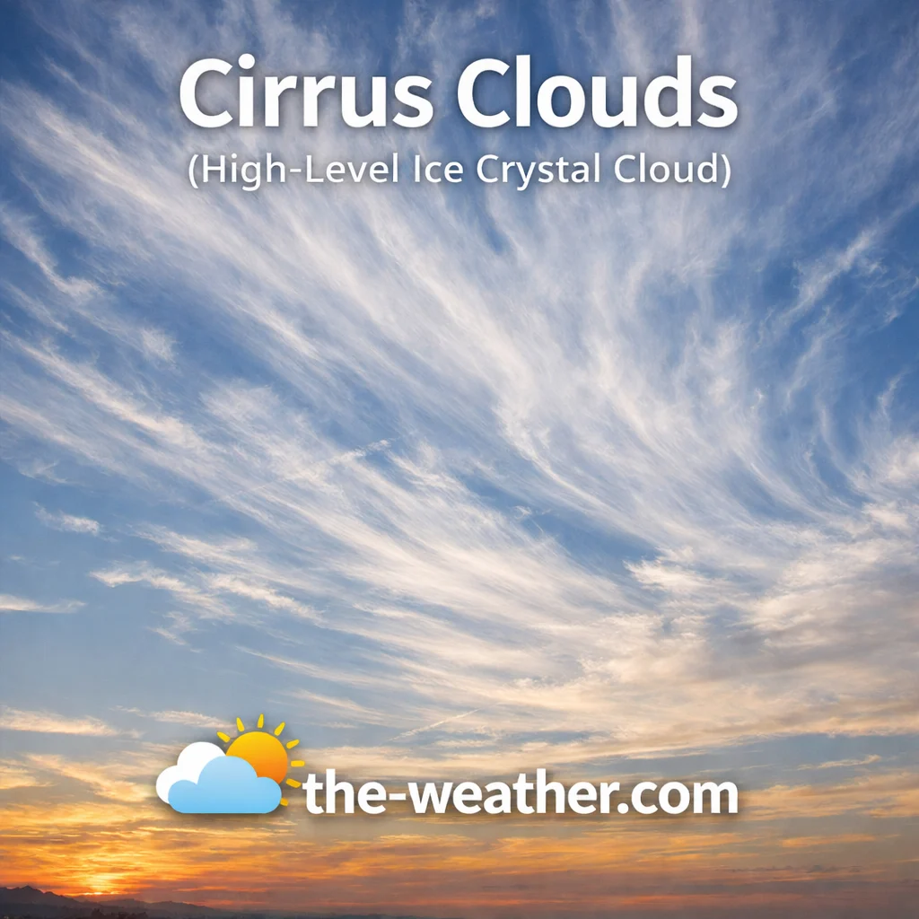
Wispy cirrus above 20,000 ft.
Cirrus clouds represent the most common type of high-altitude formation, situated in the frigid upper troposphere. At these heights, usually exceeding 20,000 feet, temperatures are perpetually below freezing, meaning these clouds are composed entirely of ice crystals. This ice-based composition gives them their distinctive silky, fibrous appearance, often likened to delicate strands of hair or “mare’s tails.” Identification is relatively straightforward: look for white, wispy strands that appear to be pulled across the sky by high-altitude winds. They are often translucent, allowing sunlight or moonlight to shine through clearly.
While often seen on sunny days, cirrus clouds serve as an atmospheric early-warning system. They are frequently the first visible signs of an approaching warm front. If you notice these clouds thickening and gradually lowering over several hours, it is a reliable indicator that moisture is increasing and that rain or snow may arrive within the next 24 to 36 hours. Their movement can also reveal the location of high-altitude jet streams, making them essential for aviation forecasting. Unlike lower clouds, cirrus never produce precipitation that reaches the ground, but their role in reflecting solar radiation and trapping heat makes them a key component of the Earth’s climate system. For more on these ice crystal signals, see our cirrus cloud characteristics guide.
Cirrostratus (High-Level Halo-Forming Cloud)

Cirrostratus creates a sun halo.
Cirrostratus appears as a thin, whitish, transparent veil that blankets large portions of the sky. Unlike the isolated strands of cirrus, cirrostratus forms a continuous sheet that gives the sky a milky or hazy appearance. These clouds are remarkably thin—so transparent that they rarely obscure the outlines of the sun or moon. However, they are most famous for producing the 22-degree halo effect. This optical phenomenon occurs when sunlight or moonlight passes through the hexagonal ice crystals within the cloud layer and refracts at a specific angle, creating a perfect circle of light around the celestial body.
Observing a “ring around the sun” is one of the most reliable weather proverbs, often preceding a warm front by 12 to 24 hours. The presence of cirrostratus signals that moisture is rising over a massive area at high altitudes. While they do not produce rain themselves, they mark the beginning of a cloud-lowering sequence that leads to precipitation. As the moisture layer thickens and the altitude drops, cirrostratus will transform into the darker, mid-level altostratus. Because they are so widespread, they can be mistaken for simple pollution, but the distinct halo proves their high-altitude nature. Understanding this layer is essential for cirrostratus cloud identification and predicting incoming fronts.
Cirrocumulus (High-Level Mackerel Sky Cloud)
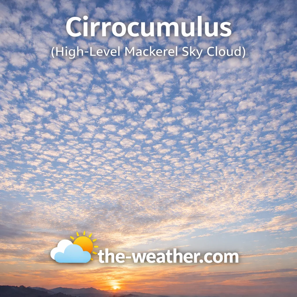
The classic mackerel sky pattern.
Cirrocumulus clouds are among the most visually striking high-altitude formations. They appear as small, white ripples or patches, often arranged in organized rows or grains. These individual elements are very small—roughly the size of a fingernail when your arm is extended toward the sky. This formation is famously known as a “mackerel sky” because the organized ripples resemble the scales of a mackerel fish. Like other clouds in the high-level family, they are composed of ice crystals, though they represent a higher level of atmospheric instability than cirrus or cirrostratus.
The formation of cirrocumulus indicates that while the air is cold and high, there is enough convective energy to break the moisture into distinct “cloudlets.” Unlike lower altocumulus, cirrocumulus clouds never cast shadows on the ground and are always white or light gray. They are relatively short-lived and will often transition into cirrus as wind conditions change. Their presence indicates that there is significant moisture and vertical motion occurring miles above the surface. In tropical regions, these clouds can sometimes be seen on the outer edges of approaching hurricane systems. Because they represent a dynamic state of the upper troposphere, they are a favorite for weather photographers. Explore the characteristics of this pattern in our cirrocumulus mackerel sky guide.
Altostratus (Mid-Level Layer Cloud)

Gray altostratus sheet.
Altostratus clouds are mid-level formations that appear as a uniform, gray or bluish-gray sheet covering the entire sky. Altostratus forms when a broad layer of moist air is lifted gradually over a large area, causing condensation at mid-level altitudes (between 6,500 and 20,000 feet). Unlike the higher cirrostratus, this layer is thick enough to significantly dim the sun, making it appear as if you are looking through “ground glass” or a frosted lens. While the sun’s position might still be visible, it will not cast a sharp shadow on the ground, which is a reliable way to identify this cloud type.
Their uniform appearance often causes confusion with lower stratus clouds, but altostratus is found at higher altitudes and has a more fibrous texture. These formations usually consist of a mixture of water droplets and ice crystals. They often form ahead of a warm front, where moist air is being lifted over a cooler air mass. As the lifting continues, the altostratus layer will thicken and lower, eventually transitioning into nimbostratus. While they may produce light “virga” (rain that evaporates before hitting the ground), they primarily signal that steady, widespread precipitation is likely within hours. Recognizing this transition is vital for short-term forecasting. You can explore more about these mid-tier signals in our guide to altostratus weather patterns.
Altocumulus (Mid-Level Patch Cloud)
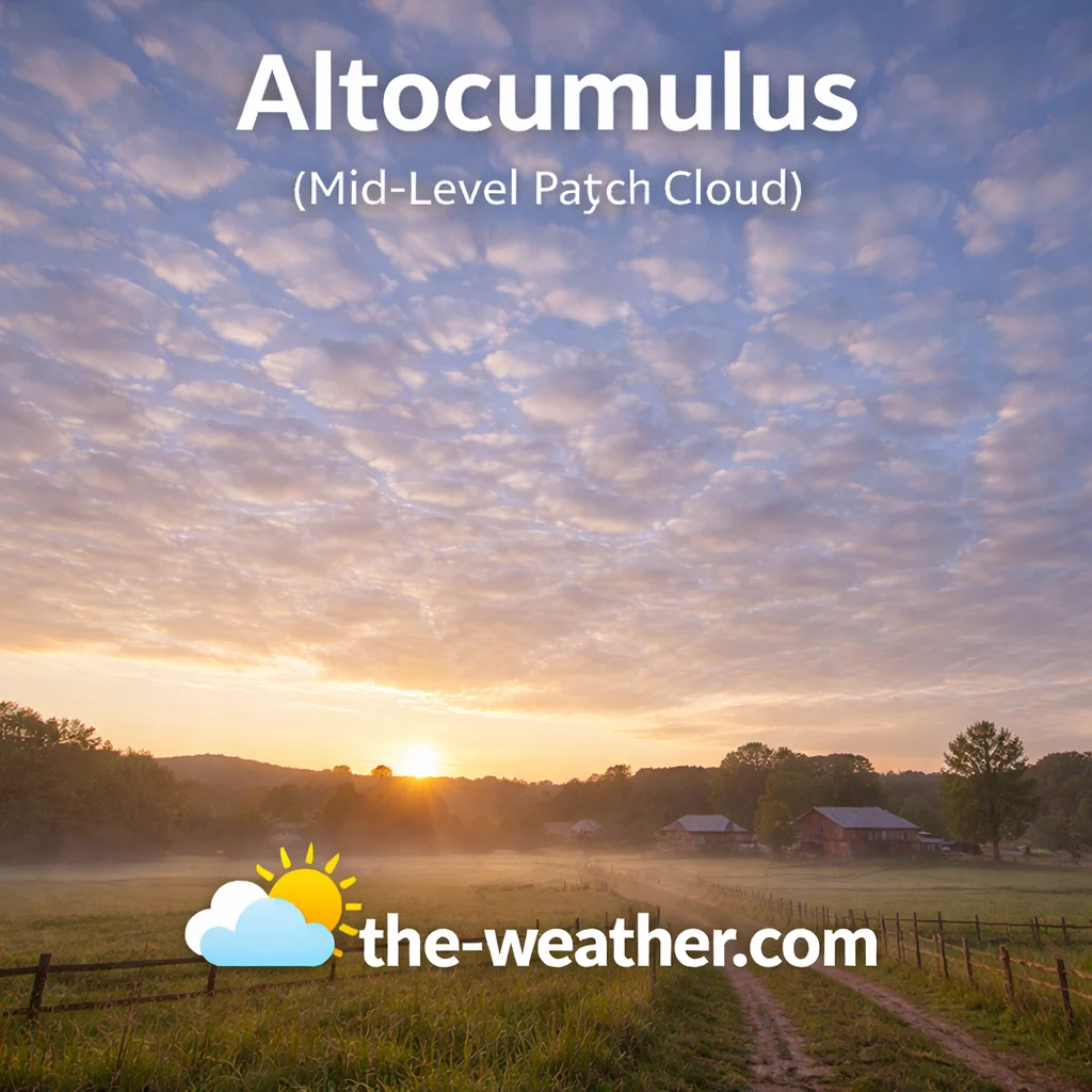
Rows of puffy altocumulus.
Altocumulus clouds are among the most diverse mid-level formations. They usually appear as gray or white sheets composed of individual rounded masses or rolls. These “cloudlets” are larger than those found in high-level cirrocumulus but smaller than the elements of low-level stratocumulus. A helpful rule for identification is that an individual altocumulus element will be roughly the size of your thumb when holding your hand at arm’s length toward the sky. They often appear in organized patches or as a series of parallel rows.
A specific form known as “castellanus”—resembling small castle towers—indicates that the middle atmosphere is becoming unstable. Seeing these towers grow taller on a warm, humid morning is a very strong signal that thunderstorms may develop by the afternoon. This instability is a key indicator for meteorologists tracking summer storm cycles. Although altocumulus themselves do not typically produce rain, their presence suggests that moisture is increasing in the mid-layers of the troposphere. The textured look often earns them the nickname “sheep clouds.” For a deeper look at these convection signals, see our page on altocumulus cloud convection signals.
Nimbostratus (Low-Level Continuous Rain Cloud)

Heavy, rain-bearing nimbostratus.
Nimbostratus is the primary cloud responsible for widespread and persistent precipitation. While the base typically sits below 6,500 feet, its vertical mass can reach significantly higher into the mid-levels, creating a dense, dark, and opaque barrier that completely obscures the sun. Unlike the high-energy outbursts of a thunderstorm, nimbostratus is characterized by the slow, large-scale ascent of moist air. This process results in moderate rain or snow that can last for many hours or even days. Visually, these formations are featureless—a dark, wet-looking gray blanket.
Beneath the main cloud base, it is common to observe “scud” clouds—ragged fragments of stratus fractus that form as the air below becomes saturated. A key factor in identifying this type is the absence of lightning, thunder, or hail; the environment remains stable but saturated, leading to a “heavy” atmosphere that limits horizontal visibility over vast areas. Observing nimbostratus is essential for understanding long-term moisture cycles. These layers represent an efficient conversion of atmospheric vapor into ground-level water, making them critical for agricultural planning. To understand how these heavy layers differ from shorter rain bursts, explore our guide on nimbus cloud rain behavior.
Stratus (Low-Level Gray Blanket Cloud)
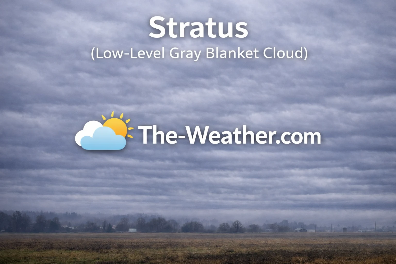
A low-hanging stratus blanket.
Stratus clouds are the lowest-hanging formations, often appearing as a uniform gray layer that lacks any distinct individual elements. In many contexts, stratus is effectively fog that has lifted slightly above the ground. These clouds typically form when cool air moves over a warmer, moist surface or when air is gently lifted along low-lying terrain. They rarely display any intricate texture, instead presenting a flat, monotonous appearance that can give the sky an oppressive, gloomy feel. They serve as a foundational example of low-level moisture processes in the atmosphere.
Precipitation associated with stratus is almost exclusively limited to fine mist, light drizzle, or small snow grains. The atmosphere is generally very stable, lacking the vertical energy required for heavy downpours. In mountainous regions, these clouds often hug the slopes, creating hazardous visibility. Along coastal zones, they are a frequent sight during the morning hours, often retreating toward the ocean as daytime heating causes the air to dry. Despite their dull nature, stratus clouds are vital to the Earth’s radiation balance, reflecting solar energy back into space. For a deeper look at these low-tier veils, see our guide on stratus cloud characteristics.
Stratocumulus (Low-Level Puffy Layer Cloud)
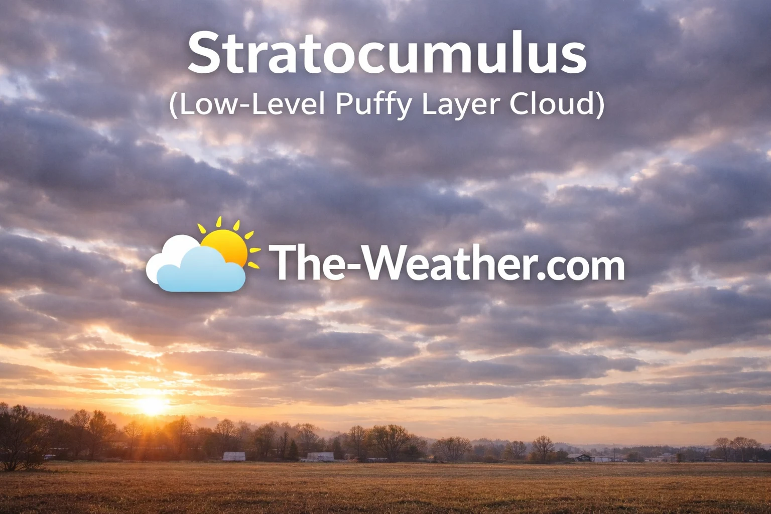
Lumpy stratocumulus rolls.
Stratocumulus clouds are identified by their lumpy, rounded masses that often congregate into organized layers or sprawling patches. These formations are typically whitish or gray and are distinguished by the darker shading visible on their undersides. Formation usually occurs when weak convective currents are capped by a temperature inversion, trapping moisture in a localized layer. While they can cover the entire sky, they frequently show small breaks of blue sky between the rolling cloud elements, creating a distinctive honeycomb-like texture that differs from the solid sheet of stratus.
Although they often appear heavy and dark, stratocumulus clouds rarely produce more than a light sprinkle or stray snow flurries. They are frequently found in the wake of a cold front, signaling that the atmosphere is beginning to stabilize even though low-level moisture remains. A common identification tip is to compare them to the higher altocumulus; stratocumulus elements are significantly larger, appearing roughly the size of a closed fist at arm’s length. This proximity to the ground makes them one of the most visible clouds over the global oceans. If the rolls begin to flatten, it suggests a transition into stratus. To explore the structure of these low-level rolls, read our guide to stratocumulus cloud identification.
Cumulus (Low-Level Fair Weather Cloud)
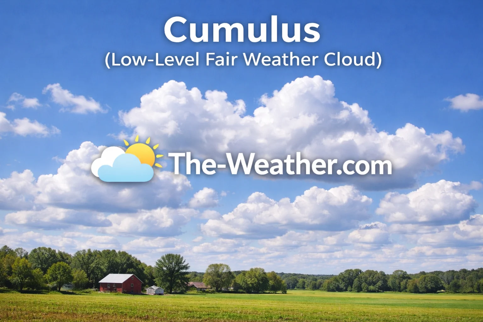
Puffy fair-weather cumulus.
Cumulus clouds feature sharp, distinct outlines and flat bases, resembling fluffy cotton balls or heads of cauliflower. The flat bottom of a cumulus cloud marks the condensation level—the altitude where rising air has cooled enough for vapor to turn into droplets. Small, scattered versions (cumulus humilis) are synonymous with fair weather and stable conditions. However, when these clouds begin to swell vertically, they transition into “cumulus congestus,” signaling that the atmosphere is becoming increasingly unstable. This vertical growth is a sign of increasing moisture and heat energy.
While fair-weather cumulus rarely produce rain, their taller counterparts can generate brief, localized showers. They represent a dynamic state of the atmosphere, where solar heating triggers the convective lift required for formation. Distinctive for their bright white tops and darker bases, they are a favorite for students of weather science. Monitoring their daily cycle—usually forming in the late morning and dissipating by sunset—is a great way to understand the basics of local convection. For more on how these fluffy formations evolve into storms, see our post on cumulus clouds and weather meaning.
Cumulonimbus (Vertical Thunderstorm Cloud)
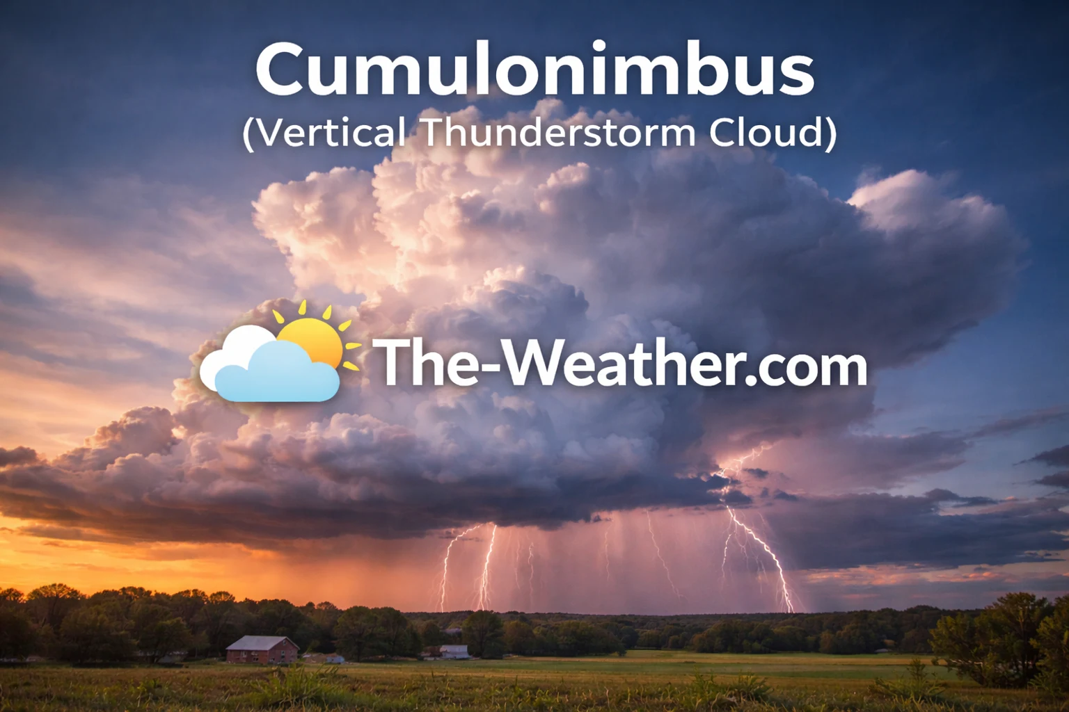
Massive thunderhead with anvil top.
Commonly referred to as the “King of Clouds,” cumulonimbus is the most powerful and dangerous of all cloud types. These massive formations are unique because they span the entire depth of the troposphere, with bases near the surface and tops that can reach 50,000 feet or more. A cumulonimbus forms when strong convective currents or atmospheric fronts force moist air to rise rapidly and violently. As the cloud hits the tropopause, the air spreads out horizontally, creating the characteristic “anvil” shape that is a hallmark of a mature thunderstorm.
From a forecasting standpoint, cumulonimbus is the primary source of severe weather, including lightning, heavy downpours, damaging winds, and hail. In extreme cases, these vertical giants can spawn tornadoes. The internal structure is highly turbulent, featuring violent updrafts and downdrafts. Identifying these towering structures early is essential for aviation safety and severe weather preparation. The presence of an “overshooting top”—a dome-like protrusion above the anvil—suggests a particularly intense storm system. Because they represent such a high concentration of energy, they are a focal point for modern meteorology. To explore the internal mechanics of these giants, read our guide on cumulonimbus cloud storm characteristics.
Official Cloud Classification Standards
The cloud classification system used in this guide follows the internationally recognized standards established by the World Meteorological Organization (WMO) International Cloud Atlas . The WMO defines the official global framework for cloud genera, altitude groupings, and structural development used in modern meteorology.
Altitude ranges, formation processes, and precipitation behavior referenced throughout this article are aligned with educational materials from the National Oceanic and Atmospheric Administration (NOAA) and the U.S. National Weather Service. These institutions provide the scientific standards applied in operational forecasting, aviation meteorology, and atmospheric research.
All ten cloud types discussed on this page, including Cirrus, Cirrostratus, Altostratus, Nimbostratus, Cumulus, and Cumulonimbus, are categorized according to the internationally accepted high-level, mid-level, low-level, and vertical development structure adopted in contemporary atmospheric science.
Sources accessed February 17, 2026.
Recommended Books for Cloud Identification

If you want to go deeper than basic cloud charts, a dedicated cloud identification field guide can dramatically improve your understanding of altitude layers, cloud genera, and weather patterns.
Detailed photography, atmospheric diagrams, and structured classifications make it easier to distinguish between similar formations such as altostratus vs. nimbostratus or cirrocumulus vs. altocumulus. Many meteorology students and aviation enthusiasts rely on these guides for accurate sky observation.
View Cloud Identification BooksDisclosure: As an Amazon Associate, we may earn from qualifying purchases at no extra cost to you.
Common Questions About the 10 Types of Clouds
What are the 10 types of clouds?
The 10 primary types are Cirrus, Cirrostratus, Cirrocumulus, Altostratus, Altocumulus, Nimbostratus, Stratus, Stratocumulus, Cumulus, and Cumulonimbus.
Which cloud produces the most rain?
Nimbostratus produces steady, long-duration rain, while Cumulonimbus produces intense thunderstorms and flash flooding bursts.
What is the highest cloud in the atmosphere?
Cirrus clouds are the highest in the troposphere, forming at altitudes above 20,000 feet where the air is freezing.
Do all clouds produce rain?
No. Only Nimbus and Cumulonimbus are primary rain-producers. Others like Cirrus or Stratocumulus may only produce light mist or virga.